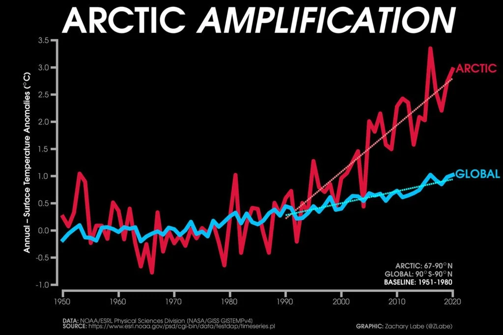
News: While the Earth’s surface as a whole has warmed by around 1.2*C since the industrial revolution, temperatures are not rising at the same rate in all corners of the world.
One difference is the faster pace that land areas are warming compared to the ocean. But perhaps the biggest outlier is the Arctic, which is warming more than two times faster than the global average.
This phenomenon – known as “Arctic Amplification” –has also been linked to extreme weather events in the mid-latitudes of the northern hemisphere.
Analysis: Scientists have identified several factors driving this amplified warming in the Arctic region.
Loss of sea ice
Ice is more reflective and less absorbent of sunlight than land or the surface of an ocean. When ice melts, it typically reveals darker areas of land or sea, and this results in increased sunlight absorption and associated warming.
In more technical terms, losing sea ice reduces Earth’s albedo as ice has a much higher albedo than water.
Albedo is the fraction of light that is reflected by a body or surface. The lower the albedo, the more a surface absorbs heat from sunlight rather than reflecting it back to space.
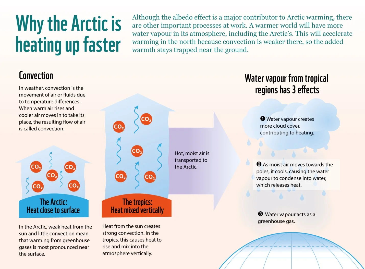
Absence of convection at higher latitudes
One of the key reasons more warming occurs at high latitudes is the absence of convection at high latitudes.
Convection occurs when air close to the ground is heated by the warm surface of the Earth. The warmed air is lighter than the cold air above and so starts to rise.
In the tropics, the ground – and the air directly above it – is always heated by the sun, hence there is a lot of convection and the atmosphere is “well mixed” with so much rising air.
At higher latitudes, the angle of solar radiation is smaller, causing energy to be spread over a larger area of the surface causing cooler surface temperatures which also means there is much less vertical mixing.
The added warming from the CO2 and other greenhouse gases that humans have emitted generally heats the atmosphere most near the Earth’s surface.
In the tropics, this extra warmth gets spread vertically due to convection. But in the Arctic, the warming from greenhouse gases is most pronounced near the surface.
Water Vapour
Another key reason for amplified warming in the Arctic is the increase in transport of water vapour from the equator to the poles.
The warm moist air from the tropics gets transported to the poles by the circulation of the atmosphere, and keeps the difference in temperature between the equator and the poles relatively small.
As a warmer atmosphere can hold more moisture, we expect there to be more water vapour in the tropical atmosphere as global temperatures rise.
This additional moisture gets transported to the poles, where it has a threefold impact on Arctic surface temperatures:
First, water vapour itself acts as a greenhouse gas, contributing to additional warming.
Second, as the moist air moves toward the poles, it cools, causing the water vapour to condense into liquid water, which releases heat into the atmosphere and further warms the region.
Third, the increased moisture leads to more cloud cover, which tends to warm the Arctic.
Seasonal differences
An additional important feature of Arctic amplification is that it occurs mostly in winter.
This is mostly due to Arctic sea ice decline. Liquid water has a large “heat capacity” – it takes a long time to heat up and cool down.
Hence when sea ice melts in summer and early autumn, it leads to an increase in sunlight absorbed by the Arctic ocean.
This stored heat is then released in winter when there is no sunlight and the atmosphere is colder than the underlying Arctic ocean.
Effects of Arctic warming
More intense heatwaves
The Arctic and Antarctic are the world’s refrigerator. Since they are covered in white snow and ice that reflect heat back into space, they balance out other parts of the world that absorb heat. Less ice means less reflected heat, meaning more intense heatwaves worldwide.
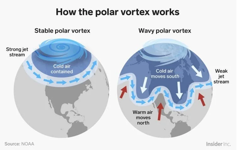
Weakening of polar jet stream
One of the most significant effects of Arctic amplification is the weakening of west-to-east polar jet stream in the northern hemisphere.
The polar jet stream is a concentrated pathway of air in the upper atmosphere which drives the weather patterns across the northern hemisphere.
As the Arctic warms at a faster rate than the tropics, this results in a weaker atmospheric pressure gradient and hence lower wind speeds.
The weakened jet stream meanders and brings the polar vortex further south, which results in more extreme winters in North America, Europe and Asia.
Increased circumpolar westerlies
Global climate models project stronger surface warming in the Arctic than the Antarctic under climate change. But as the tropics continue to warm and expand, we may expect an increase in the pressure gradient between the tropics and Antarctica that will lead to increased circumpolar westerlies winds.
The recent intensification and more poleward location of the southern hemisphere belt of westerly winds have been linked to continental droughts and wildfires, including those in Australia.
Effect on coastal communities
Melting ice in polar regions and the rising seas endanger coastal cities and small island nations by exacerbating coastal flooding and storm surge. Glacial melt of the Greenland ice sheet is a major predictor of future sea level rise; if it melts entirely, global sea levels could rise 20 feet.
Effect on wildlife
When there’s less sea ice, animals that depend on it for survival must adapt or perish. Loss of ice and melting permafrost spells trouble for polar bears, walruses, arctic foxes, snowy owls, reindeer, and many other species.
Permafrost
Arctic ice and permafrost—ground that is permanently frozen—store large amounts of methane, a greenhouse gas that contributes to climate change. When it thaws, that methane is released, increasing the rate of warming. This, in turn, causes more ice and permafrost to thaw or melt, releasing more methane, causing more melting.
Why Arctic is warming faster than Antarctica
The absence of convection and water vapour also affect Antarctica and lead to amplified Antarctic warming. In fact, the Antarctic continent has not warmed in the past seven decades, despite a steady increase in the atmospheric concentrations of greenhouse gases.
However, polar amplification is much stronger in the Arctic than in Antarctica. This difference is because the Arctic is an ocean covered by sea ice, while Antarctica is an elevated continent covered in more permanent ice and snow.
Also, amplified Antarctic warming is delayed due to the Southern Ocean circulation, which brings up cold water from the deep ocean and cools the surface.
Cutting Emissions is the best solution
Cutting emissions can slow the rate of warming until the Earth’s temperature stabilizes when we reach net zero.
But until we are able to remove more carbon dioxide from the atmosphere than we put in, the temperature will not go down.
For this reason, there is increasing interest in so-called solar climate interventions—such as marine cloud brightening and stratospheric aerosol injection—that aim to cool the climate intentionally by increasing the amount of sunlight reflected to space.
Note: The Earth has kept a record of its past climates, and scientists today can analyse various “proxies” – such as shells, stalactites (icicle-shaped formations that hang from the ceiling of a cave), pollen and seal pelts – to deduce the global climate going back many millions of years.
Heatwaves in India: Causes, Effects, Prediction and Mitigation
News: The India Meteorological Department (IMD) has announced above-average heat wave days for India.
Total duration of heatwaves in India has increased by about three days during the last 30 years and a further increase of 12-18 days is expected by 2060.
What is a Heatwave?
A period of abnormally high temperatures is called a heatwave. The India Meteorological Department (IMD) declares a heat wave if the maximum temperature of a weather station reaches at least 40 degrees C in the plains and at least 30 degrees C in hilly regions, with a departure of around 4.5-6.4 degrees C from the normal maximum temperature.
The IMD can also declare a heat wave if the actual maximum temperature crosses 45°C (or 37°C at a hill-station), and a ‘severe heat wave’ if it crosses 47°C.
Qualitatively, a heat wave can also occur when the temperature of the air becomes fatal to the human body.
Heat waves in India are typically recorded between March and June and tend to peak in May.
Heatwaves in India
Heat waves in India are typically recorded between March and June and tend to peak in May.
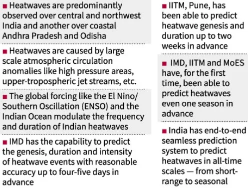
Heatwaves are predominantly observed over two areas,
central and northwest India and
another over coastal Andhra Pradesh and Odisha.
Heatwaves are common over the Core Heatwave Zone (CHZ) — Rajasthan, Punjab, Haryana, Chandigarh, Delhi, West Madhya Pradesh, Uttar Pradesh, Chhattisgarh, Orissa, Vidarbha in Maharashtra, parts of Gangetic West Bengal, Coastal Andhra Pradesh and Telangana, as categorised by India Meteorological Department.
Causes of heatwaves in India
A study published on February 20, 2023, in Nature Geoscience offers explanations as to how different processes contribute to the formation of a heat wave. (The study’s findings have been adapted here to the Indian context. Source: The Hindu)
First of all, in spring, India typically has air flowing in from the west-northwest.
In the context of climate change, West Asia is warming faster than other regions in latitudes similarly close to the equator, and serves as a source of the warm air that blows into India.
Likewise, air flowing in from the northwest after crossing the mountains of Afghanistan and Pakistan gets compressed and thus gets heated while descending the leeward side of these mountains and enters India as a warm wind.
While air flowing in over the oceans is expected to bring cooler air, the Arabian Sea is unfortunately warming faster than most other ocean regions.
Next, the strong upper atmospheric westerly winds, that come in from the Atlantic Ocean over to India during spring, descends, compresses, and warms up to generate some heatwaves.
Finally, the so-called lapse rate — the rate at which temperatures cool from the surface to the upper atmosphere — is declining under global warming.
In other words, global warming tends to warm the upper atmosphere faster than the air near the surface.
This in turn means that the sinking air is warmer due to global warming, and thus produces heatwaves as it sinks and compresses.
Heatwaves and El Nino-La Nina phenomenon
In 2022 itself, the heatwaves started early and were more numerous.
They also extended further south into peninsular India due to a north-south pressure pattern set up by the La Nina.
La Nina is a world-affecting weather phenomenon in which a band of cool water spreads east-west across the equatorial Pacific Ocean.
The El Niño is a complementary phenomenon in which warmer water spreads west-east across the equatorial Pacific Ocean.
Heatwaves tend to be confined to north and northwest India in El Niño years.
Anticyclones and heatwaves
Anticyclones over western and north-western parts of India in March and the absence of western disturbances can also trigger the early and extreme heatwaves.
Anticyclones cause hot and dry weather by sinking winds around high-pressure systems in the atmosphere.
How does air mass contribute to heatwaves?
The north-northwestern heatwaves are typically formed with air masses that come from 800-1,600 km away and are around two days old.
Heatwaves over peninsular India arrive from the oceans, which are closer and are barely a day old. As a result, they are on average less intense.
Prediction of heatwaves in India
Under the National Monsoon Mission, the Ministry of Earth Sciences (MoES) had established an advanced prediction system for early warnings of heatwaves.
India Meteorological Department (IMD) has the capability to predict the genesis, duration and intensity of heatwave events with reasonable accuracy up to four-five days in advance.
Can we then predict heatwaves two weeks in advance and what about a season in advance?
The Indian Institute of Tropical Meteorology (IITM), Pune, has shown that heatwave genesis and duration in India can be predicted with good skill up to two weeks in advance.
Improved prediction
Scientists from IMD, IITM and MoES have documented for the first time that Indian heatwaves can be predicted even one season in advance.
Heat Wave Impacts
Water resources : Heat wave intensifies the water crises in several regions, especially in arid and semi-arid areas.
Wild/Forest fires : Wildfires occurs in uncommon areas such as the Arctic. Forest Survey of India has estimated that 21.4 per cent area under forest is vulnerable to forest fires.
Energy consumption: Power outages are triggered by the disproportionally high electricity demand due to air-conditioning during heatwaves.
Crops: High temperatures beyond certain optimum level reduce plant growth.
In higher plants, heat stress significantly alters cell division and cell elongation rates which affect both leaf size and leaf weight.
As stress increases, closure of stomata slows down or stops CO2 diffusion.
Several districts of Punjab were affected with heat wave events due to increase in temperature which has resulted in yellowing and shriveling of wheat grain, wilting and forced maturity, lower grain weight, resulting in reduction in yields up to 25%.
Fisheries: With global warming, tropical and subtropical areas will experience more reduction in ecosystem productivity than temperate and polar ecosystems, with rapid poleward shifts in distributions of fish and plankton.
Sea level rise due to glacier melting will destroy the mangrove forest as well as destroy the marine fish nursery ground.
With rising temperature, the physiological activity of the fishes also increases with increase in oxygen demand, whereas the solubility of the oxygen in water is inversely related to temperature and salinity.
High temperature can cause stratification leading to algae blooms and reduced levels of dissolved oxygen.
GS Paper 2
Kachchatheevu Island Dispute: Causes and Solutions
News: The encroachment by Tamil Nadu fishermen in Sri Lankan waters in search of profitable catch and their detention by the Sri Lankan Navy have often caused friction in Indo-Sri Lankan ties.
In order to maintain amiable bilateral relations, concurrent with India’s “Neighbourhood First” policy, resolving this fishing dispute has assumed greater significance.
The government of Tamil Nadu alleges that the Indo-Sri Lankan fishing dispute is a direct consequence of the “unlawful” ceding of Kachchatheevu to Sri Lanka.
Analysis
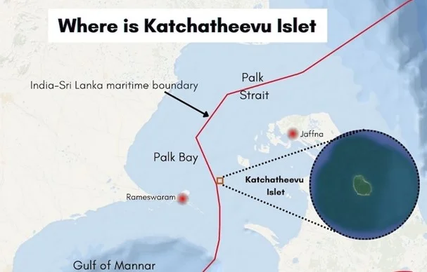
Where is Kachchatheevu located?
Katchatheevu, in the Palk Strait, is a tiny island, measuring 285.20 acres, and is located about 14 nautical miles from Rameswaram in India.
The proximity of the isle to both countries, India and Sri Lanka, has been the cause of its being a bone of contention between the two nations for decades now.
Why did India give awayKachchatheevu to Sri Lanka?
Treaties were signed between Sri Lanka and India in 1974 and 1976, to demarcate the maritime boundary — the International Maritime Boundary Line (IMBL).
Under these agreements, India recognized Sri Lanka’s sovereignty over Kachchatheevu whilst gaining sovereignty over Wadge Bank in return.
This decision was undertaken in order to cement friendly relations between the two countries and prevent ties from souring in the future over the relatively minor matter of the small uninhabited island.
Described by Indira Gandhi as a “sheer rock with no strategic significance”, she could not have foreseen the animosity this uninhabited island would generate amongst Tamils from both sides of the border which continues to haunt India-Sri Lanka relations today.
India gets Wadge Bank
On the day of signing the second agreement in March 1976, India and Sri Lanka inked another understanding regarding ownership of Wadge Bank, a 10,000-square-kilometres’ undersea plateau situated nearly 50 kilometres south of Kanyakumari in Tamil Nadu. Through this understanding, Sri Lanka recognised India’s sovereignty over Wadge Bank and its rich marine resources.
At the time of signing the agreement, Wadge Bank fell under India’s exclusive economic zone but outside its territorial waters. Traditionally, fishermen from both India and Sri Lanka carried out fishing in this area. As part of the agreement, a certain number of licensed fishers from Sri Lanka were allowed in Wadge Bank for three years.
Can India retrieve Kachchatheevu Island?
Both countries have notified the two agreements signed in 1974 and 1976 under the UN Convention on the Law of the Seas (UNCLOS) – an international agreement that provides the legal framework for all marine and maritime activities.
The agreement noted Article 15 of the UNCLOS which exempted the use of median line to determine the IMBL (International Maritime Boundary Line), and recognised the adjustments agreed to it by the contracting nations. Due to this, the Katchatheevu island fell on the Sri Lankan side of the IMBL.
In addition to that, the agreements entered into by India and Sri Lanka are binding under the Vienna Convention on the Law of Treaties, 1969 (VCLT). There are no provisions in both the Agreements that address either withdrawal or termination.
India cannot unilaterally revoke the agreement and to withdraw India needs to notify Sri Lanka and acquire its consent. Sri Lanka had staunchly opposed any change to the status quo on the maritime boundary with India.
Why do Indians cross the Maritime boundary?
Bottom-trawling by Indian fishermen has contributed to the destruction of their primary source of livelihood by depleting the fisheries in Indian waters.
These bottom trawlers not only destroy the seabed and marine ecosystem but tear the fishing nets and destroy the traditional boats of the Sri Lankan Tamils.
Between 1983 and 2009, Indian fishermen had easier access to the rich Sri Lankan waters as the maritime boundary in the Palk Strait was not heavily guarded.
Since 2009, the Sri Lankan navy has tightened surveillance of its northern maritime boundary to halt a potential return of Tamil insurgents.
This, in turn, has had the secondary effect of increasing the number of arrests of Indian fishermen.
Earlier the Sri Lankan navy used to release the boats that were confiscated when the fishermen were set free. But, now they release only the fishermen and the boats are kept with the navy.
What could be the possible solutions toKachchatheevu dispute?
Discouraging unsustainable fishing:
An unsustainable fishing practice known as bottom trawling, which tows a net along the ocean floor to catch fish and other marine species – commonly practiced by Indian fishers — has come in the way of efforts to resolve the dispute between the two countries.
Experts say that in addition to netting the targeted fish species and shrimps, this method pulls in a variety of marine life, including coral and seaweed. This method has been blamed for the depletion of marine resources in large parts of Palk Bay, especially on the Indian side.
In past negotiations, Sri Lankan authorities have agreed to “consider letting Indian fishers into their waters if, and only if, the latter gave up bottom-trawling.
The way forward is if New Delhi and Tamil Nadu are determined, they can create a win-win scenario in Palk Bay. The immediate decommissioning of trawlers is an important prerequisite for this unconventional solution.
Other suggestions may include permitting a limited number of Indian and Sri Lankan fishers into each other’s waters up to a certain distance from the IMBL and the promotion of deep-sea fishing among Indian fishermen.
Palk Bay Scheme:
In order to prevent Tamil Nadu fishermen from crossing the IMBL, the Centre had announced a ₹1,600 crore ‘Palk Bay Scheme’, under which around 2,000 trawlers were to be replaced with deep sea fishing vessels.
Of the unit cost of each vessel (₹80 lakh), 50% would be borne by the Centre, 20% by the State government and 10% by the beneficiary, and the remaining 20% would be met through institutional financing.
More importantly, the Centre feels that deep sea fishing is the “only solution” to promote ecologically sustainable fishing and reduce “fishing pressure” around the close proximity of the IMBL and the incidents of cross-border fishing.
The Union government framed this scheme exclusively for Tamil Nadu, as the fishermen of the Palk Bay districts were invariably caught by the Sri Lankan authorities for crossing the International Maritime Boundary Line illegally.
However, the scheme has failed to take off, despite the passage of over six years. Lack of interest among beneficiaries to make the transition, the “unaffordable cost” of the boats for deep sea fishing, the higher operational cost per voyage and the unwillingness of banks to lend are among the reasons cited. The Union and the Tamil Nadu government need to take steps to implement the scheme with full vigour.
Conclusion
The reinstatement of the “traditional rights” of Tamil fishermen which Tamil Nadu continues to call for is short-sighted. It only serves as political rhetoric helping political parties curry favour amongst a one million strong vote base. As a responsible power, India has an obligation to abide by international law.
The bilateral relation with Sri Lanka should take precedence over the small matter of an uninhabited island which fails to provide a feasible solution to the fishing dispute. Over the years, relations with Sri Lanka have been amicable at best. Colombo’s growing closeness to China means New Delhi has to tread with caution.
The need of the hour is to incentivize fishermen towards a sustainable alternative to bottom-trawling which will safeguard the future of both the Indian and Sri Lankan fishermen without compromising Indo-Sri Lankan ties.
The willful and inadvertent transgressions into Sri Lankan waters by Indian fishermen need to be curtailed, but this will only be feasible when the livelihoods of these fishermen are secured—the duty and obligation of which rests with the Tamil Nadu and Central governments.
GS Paper 3
Indian Laurel Tree
News: Acaptivating video capturing water gushing out from a tree trunk in Andhra Pradesh has taken social media by storm.
Indian Laurel Tree:
The Indian Laurel, native to Southeast Asia, India, and Sri Lanka, was initially introduced as an ornamental tree for gardens.
Its invasive tendencies emerged in the 1980s due to the accidental introduction of a pollinating wasp.
Belonging to the Fig Family, it bears fig-like fruits containing around 150 seeds, with a single large tree capable of producing up to 100,000 fruits.
Often referred to as ‘strangling figs,’ Indian Laurels pose a threat to other trees by growing on them and endangering their survival.
Their seedlings have a remarkable ability to sprout in various environments, making them highly adaptable.
Kodaikanal
News: 125 years of Kodaikanal Solar Observatory have been completed.
Kodaikanal:
Situated in the Palani Hills within the Western Ghats, Kodaikanal was established in 1845 by U.S. missionaries and British civil servants as a hill station.
It houses a meteorological observatory engaged in astrophysical research.
The Kodaikanal Solar Observatory (KoSO), founded in 1899 and formerly part of the Madras Observatory, was established to gather data on solar heating of the Earth’s atmosphere and to study monsoon patterns.
Its location in Kodaikanal, chosen for its proximity to the equator and its dust-free high-altitude setting, underscores its significance.
Currently overseen by the Indian Institute of Astrophysics, the observatory is nestled within the Palani range in Tamil Nadu.
Punnett Square
News: Punnett squares are a way to predict the possible genetic outcomes of the offspring when two individuals with known genotypes are crossed.
Punnett Square:
A valuable tool in genetics, the Punnett Square facilitates the prediction of variations and probabilities arising from cross-breeding.
Named after British geneticist Reginald Punnett, who pioneered the approach in 1905, it has become a cornerstone in biology for comprehending inheritance patterns.
Widely employed, Punnett Squares are instrumental not only in biology but also in understanding the genetic traits passed down to offspring in various animals, including humans.
Bridge Fuel
News: Natural gas is often referred to as a ‘Bridge Fuel’ for nations aiming to move away from coal and oil dependence while progressing towards renewable energy and electrification.
Bridge Fuel:
A bridge fuel is a commonly-used term for a fuel that aims to power society with minimal environmental impact while renewable energy sources are deployed.
The objective is to replace current fossil fuel-dependent energy sources as we transition towards a cleaner, renewable energy economy devoid of greenhouse gas emissions.
Natural gas is often regarded as a bridge fuel due to its comparatively lower greenhouse gas emissions during combustion.
However, other factors to consider for a bridge fuel include its potential to enhance national energy independence while reducing pollution-related costs.
Facts for Prelims
National Information System for Climate and Environment Studies (NICES) Programme
News: The National Information System for Climate and Environment Studies (NICES) programme has invited Indian researchers to join in combating climate change.
Definition: NICES is operated by the Indian Space Research Organisation (ISRO) and the Department of Space, along with other ministries and institutions, under the framework of the National Action Plan on Climate Change.
It was conceptualised in 2012 as part of efforts to monitor climate variability and climate change from space.
Objective:
To disseminate long-term Essential Climate Variables (ECVs) derived from EO satellites, critical for characterizing Earth’s climate.
These data sets have been instrumental in documenting climate change and its impacts, serving as vital resources for researchers and policymakers alike.
Aim: The NICES programme now aims to enhance the participation of academia and research institutions in addressing climate change-related challenges through dedicated multidisciplinary scientific investigations.
Prospective areas for project submission include Space-based ECVs and Climate Indicators, Climate Change Challenges, Weather Extremes, and Climate Services, among others.
Importance:
By harnessing the power of space-based data and fostering collaborative research efforts, NICES aims to advance our understanding of climate dynamics and inform evidence-based policy interventions.
It is imperative to note that since its inception, NICES has produced over 70 geophysical variables relating to terrestrial, oceanic, and atmospheric conditions, essential for understanding Earth’s climate dynamics.