What are El Nino and La Nina?
- El Nino is an abnormal warming of water (at least 0.5 degrees Celsius warmer than the long-term average) in the central and eastern tropical Pacific Ocean off the northern coast of South America every two to seven years.
- In the case of a strong El Nino event as occurred in 2015-2016, anomalies can reach as high as 3°C, which is a record.
- An El Nino year creates a miniature global-warming crisis, since the warm water spreading across the tropical Pacific releases a large amount of heat into the atmosphere.
- An El Nino phenomenon usually has higher influence on the global climate during the second year of its development.
- Climate records of El Nino go back millions of years, with evidence of the cycle found in ice cores, deep sea muds, corals, caves and tree rings.
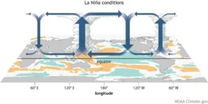
- There is also an opposite of an El Nino, called La Nina. This refers to times when waters of the tropical eastern Pacific are colder than normal and trade winds blow more strongly than usual. Typically, El Ninos occur more frequently than La Ninas.
- La Nina events may last between one and three years, unlike El Nino, which usually lasts not more than a year.
- Both phenomena tend to peak during the Northern Hemisphere winter (Dec-Jan-Feb).
- During the past two decades (2000-2020), the La Nina years experienced almost double the number of intense cyclones compared to the El Nino years in North Indian Ocean region.
- According to the World Meteorological Organization (WMO), the 2023-24 El Nino phenomenon, experienced globally, is one of the five strongest on record, though it was weaker than the 1997-98 and 2015-2016 events.
Read also: Anthropocene Epoch: Definition, Significance & Controversies | UPSC
What causes an El Nino?
- Scientists do not yet understand in detail what triggers an El Nino cycle.
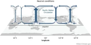
- Normally, due to the presence of cold Peru Current (Humbolt Current) along the coast of Peru (South America), there is high pressure area in the eastern Pacific Ocean along the Peru Coast.
- Therefore, air moves from the eastern Pacific Ocean to the western Pacific Ocean where there is comparatively a low pressure.
- Because of the warmer oceans this air gets lots of moisture due to evaporation on the way.
- This warm moist air rises to high levels of the atmosphere in the western part of the Pacific Ocean and causes rainfall in Indonesia, eastern and northern Australia etc.
- The rise of warm air finally results in its cooling in the upper atmosphere. A part of this air moves towards the eastern Pacific Ocean in the upper atmosphere and descends over the eastern Pacific Ocean and helps to sustain the higher pressure there and again moves towards the western Pacific Ocean.
- This way we have a complete circulation of air between eastern and western Pacific Ocean. This circulation is called Walker Circulation.
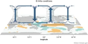
- During El Nino years, due the abnormal warming of water in the central and eastern tropical Pacific Ocean the high pressure area in the eastern Pacific Ocean weakens, thus the wind moving towards the east (called easterly wind) weakens or even reverses its direction.
- Thus, there is less rainfall/drought in the western Pacific Ocean (Indonesia, eastern and northern Australia and nearby areas including India etc.) whereas due to the presence of warm water in the eastern Pacific Ocean near Peru cloud formation takes place which causes heavy rainfall/floods in the coastal Peru.
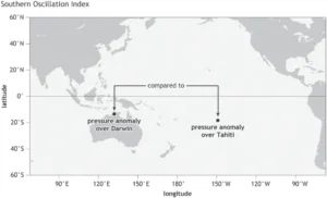
- The atmospheric pressure in the eastern Pacific Ocean is measured at a place called Tahiti whereas the atmospheric pressure in the western Pacific Ocean is measured at a place called
- During normal years there is high pressure at Tahiti and low pressure at Darwin. This situation exactly reverses during El Nino years and this phenomenon is called Southern Oscillation.
- Together, La Nina and El Nino are the “cold” (La Nina) and “warm” (El Nino) phases of the El Nino-Southern Oscillation (ENSO).
El Nino and Indian Monsoon
- An analysis of rainfall records of the past 132 years has revealed that severe droughts in India have always been accompanied by El Nino events, but not all such weather conditions have led to the failure of monsoons.
- The El Nino events in 1965, 1972, 1982 and 1987 were bad for India but the 1997 El Nino, despite being the strongest in the century, did not affect monsoons (Thus, strong El Nino events are not always associated with drought).
- This led many experts to conclude that the link between monsoons and global weather event was wearing off. But the India Meteorological Department still takes into account El Nino for Monsoon forecasts.
How El Nino affects Indian Monsoon: Mechanism
- As discussed above, rising and cooling of the warm moist air in the atmosphere in the western part of the Pacific Ocean in the upper atmosphere results in its division into at least two parts.
- A part of this air moves towards the eastern Pacific Ocean in the upper atmosphere and descends over the eastern Pacific Ocean and helps to sustain the higher pressure there.
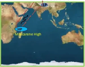
- One part also descends near East Africa and aids the formation of the Mascarene High Pressure Zone.
- This increases the difference between the high pressure in the south over Mascarene High Pressure zone and the low pressure in the Indian subcontinent. Thus, more moisture laden winds move towards the Indian Subcontinent.
- During El Nino years, due the abnormal warming of water in the central and eastern tropical Pacific Ocean the high pressure area in the eastern Pacific Ocean weakens, thus the wind moving towards the east (called easterly wind) weakens or even reverses its direction.
- Thus, less or no air descends near East Africa which results in the weakening of the Mascarene High Pressure Zone.
Location of warming
- Researchers also believe that even the location of the warming in the Pacific may possibly have an influence on the monsoon.
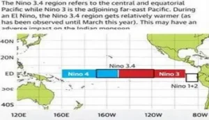
- Anomalous warming in the Central and East Pacific (Nino 3.4 region) could have a more profound adverse impact on the monsoon than when the warming shifts to the adjoining far east Pacific (Nino 3. region).
- Note: A transition from a La Nina winter to an El Nino summer historically tends to produce a large monsoon deficit, on the order of 15%.
- This means pre-monsoon and monsoon circulations tend to be weaker in an El Nino year.
- Some research has indicated that the Indian Ocean dipole — that refers to the difference in temperatures between the surface waters in the west and east over the tropical Indian Ocean — could compensate for the negative effects of an El Nino.
Note: What is Normal Monsoon?
- In case of monsoon season (June to September) rainfall over India as a whole, the long period average (LPA) is 87 cm (revised from 88 cm by IMD in April 2022) and standard deviation is 9cm (about 10% of mean value).
- Therefore, when the rainfall averaged over the country as a whole is within ±10% from its long period average (LPA) or 90% to 110% of LPA, the rainfall is said to be “normal” and when the rainfall is <90% (>110%) of LPA, the rainfall is said to be “below (above) normal”.
Other effects of El Nino
- The location of tropical storms shifts eastward during an El Nino because atmospheric moisture is fuel for thunderstorms, and the greatest amount of evaporation takes place above the ocean’s warmest water.
- Record rainfall often strikes Peru, Chile and Ecuador during an El Nino year.
- Fish catches offshore South America are typically lower than normal as during El Nino years, warm water persists and deepens, and cold, upwelling, nutrient rich water (which is present during normal years) fails to reach surface and the marine life migrates north and south, following colder water.
- Strong El Ninos are also associated with above-average precipitation in the southern tier of the United States from California to the Atlantic coast.
- Indonesia and northeastern South America tend toward drier-than-normal conditions.
- Temperatures in Australia and Southeast Asia run hotter than average.
- El Nino-caused drought and heatwaves can be widespread, affecting southern Africa, India, Southeast Asia, Australia, the Pacific Islands and the Canadian prairies.
- In general, warm El Nino events are characterized by more tropical storms and hurricanes in the eastern Pacific and a decrease in the Atlantic, Gulf of Mexico and the Caribbean Sea.
- An El Nino creates stronger wind-shear and more-stable air over the Atlantic, which makes it harder for hurricanes to form.
- However, the warmer-than-average ocean temperatures boost eastern Pacific hurricanes, contributing to more-active tropical storm seasons.
- Wind shear is defined as the amount of change in the wind’s direction or speed with increasing altitude.
- The El Nino, along with global warming, had made 2016 as one of the warmest year on record.
- The warming of the oceans is one of the major impacts of an El Nino event.
- During an El Nino, the Pacific’s warmest surface waters occurs offshore of northwestern South America (as El Nino begins when warm water in the western tropical Pacific Ocean shifts eastward along the equator toward the coast of South America. Normally, this warm water pools near Indonesia and the Philippines).
- Prevailing easterly trade winds weaken and even reverse direction during the El Nino climate phenomenon.
Miscellaneous
a) El Nino Modoki Vs La Nina Modoki
-
- El Nino can further be classified into two types:
- traditional El Nino which is characterized by strong anomalous warming in the eastern equatorial Pacific and
- the El Nino Modoki that is associated with strong anomalous warming in the central tropical Pacific and cooling in the eastern and western tropical Pacific.
- La Nina Modoki is the counter part of El Nino Modoki and is characterised by colder central Pacific being flanked by warmer eastern and western Pacific.
b) ENSO Spring Barrier or Spring Predictability Barrier
-
- The “ENSO spring barrier” or “spring predictability barrier” is often used to highlight the uncertainty in the outlook for ENSO (the El Niño – Southern Oscillation) in the first half of the year. It is more like a lull or a valley in ENSO forecasting accuracy.
- After the spring, the ability of the models to predict becomes increasingly better.
- This uncertainty is because of the tendency for the ENSO phase to shift as El Niño and La Nina episodes decay after their usual winter peak.
c) Triple-dip La Nina
-
- During the period of 2020–2023, the La Nina effect occurred for its third consecutive northern hemisphere winter, making this a rare “triple-dip” event.
- Other triple-dip La Nina’s recorded since 1950 spanned the years 1998-2001, 1973-1976, and 1954-1956.
References:
- https://www.worldclimateservice.com/2021/05/14/enso-spring-barrier/
- https://www.climate.gov/news-features/blogs/enso/spring-predictability-barrier-we%E2%80%99d-rather-be-spring-break
- https://www.icts.res.in/sites/default/files/dcs2016-2016-06-02-Nanjundiah.pdf
- https://www.thehindu.com/sci-tech/science/explained-why-india-is-watching-the-el-ni%C3%B1o-forecast-with-bated-breath/article66532483.ece
- https://www.downtoearth.org.in/blog/el-nino-la-nina-and-the-indian-subcontinent-44120
- https://www.deccanherald.com/science-and-environment/intensity-of-severe-cyclonic-storms-increasing-in-north-indian-ocean-region-study-1014244.html
- https://www.downtoearth.org.in/blog/el-nino-la-nina-and-the-indian-subcontinent-44120