Indian Summer Monsoon: Origin, Mechanism, Characteristics and Effects | UPSC
What is Monsoon?
- A monsoon is a change in the direction of the prevailing winds of a region that happens when the seasons change. In fact, even the word monsoon comes from the Arabic word mausim, which means “season.”
- Monsoon often causes a very rainy season or a very dry season and it always blows from cold to warm regions.
- Although monsoon is usually associated with parts of Asia, they can happen in many tropical and subtropical regions as well.
- Southwest monsoon is a seasonal prevailing wind in the region of South and SE Asia, blowing from the south-west between May and September and bringing rain (the wet monsoon), or from the north-east between October and April (the dry monsoon).
- India receives 75% of its rainfall from the southwest monsoon during June to September.
Onset and the retreat of the Southwest Monsoon
- During April and May when the sun shines vertically over the Tropic of Cancer, the large landmass in the north of Indian ocean gets intensely heated.
- This causes the formation of an intense low pressure in the northwestern part of the Indian subcontinent.
- This heat low gradually extends eastwards until it forms an elongated low-pressure zone running parallel to the Himalayan mountains in a west to east direction. It is called monsoon trough or the Inter Tropical Convergence Zone (ITCZ).
- Since the pressure in the Indian Ocean in the south of the landmass is high as water gets heated slowly, the low pressure cell attracts the southeast trade winds of Southern Hemisphere across the Equator.

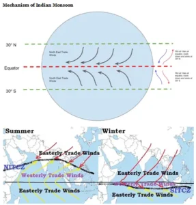
- The southwest monsoon may thus, be seen as a continuation of the southeast trade winds deflected towards the Indian subcontinent after crossing the Equator. These winds cross the Equator between 40°E and 60°E longitudes.
-
- Some also say that these currents of southwesterly monsoon are in reality ‘displaced’ equatorial westerlies. (Source: NCERT)
-
- The position of the ITCZ is also related to the phenomenon of the withdrawal of the westerly jet stream from its position over the north Indian plain, south of the Himalayas.
-
- An easterly jet stream sets in along 15°N latitude only after the western jet stream has withdrawn itself from the region.
-

-
- This easterly jet stream is held responsible for the burst of the monsoon in India.
- The rain in the southwest monsoon season begins rather abruptly. This sudden onset of the moisture-laden winds associated with violent thunder and lightning, is often termed as the “burst” of the monsoons.
- Passing over the equatorial warm currents, the southeast trade winds of Southern Hemisphere bring with them moisture in abundance.
- After crossing the equator, they follow a southwesterly direction (because of the Coriolis Effect which causes a wind moving in the northern hemisphere to deflect towards its right and a wind moving in the southern hemisphere to deflect towards its left). That is why they are known as southwest monsoons.
a) Entry of Monsoon into India
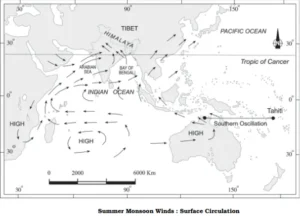
- The southwest monsoon sets in over the Kerala coast by 1st June and by mid- July, southwest monsoon engulfs the entire Subcontinent.
b) Rain-bearing Systems and Rainfall Distribution
- There seem to be two rain-bearing systems in India.
- First originate in the Bay of Bengal causing rainfall over the plains of north India.
- Second is the Arabian Sea current of the southwest monsoon which brings rain to the west coast of India.
- Much of the rainfall along the Western Ghats is orographic as the moist air is obstructed and forced to rise along the Ghats.
- The intensity of rainfall over the west coast of India is, however, related to two factors:
- (i) The offshore meteorological conditions.
- (ii) The position of the equatorial jet stream along the eastern coast of Africa.
- The frequency of the tropical depressions originating from the Bay of Bengal varies from year to year.
- Their paths over India are mainly determined by the position of ITCZ which is generally termed as the monsoon trough.
- As the axis of the monsoon trough oscillates, there are fluctuations in the track and direction of these depressions, and the intensity and the amount of rainfall vary from year to year.
- The rain which comes in spells, displays a declining trend from west to east over the west coast, and from the southeast towards the northwest over the North Indian Plain and the northern part of the Peninsula.
c) Break in the Monsoon
- During the south-west monsoon period after having rains for a few days, if rain fails to occur for one or more weeks, it is known as break in the monsoon.
- The ITCZ (monsoon trough) shows periodical movements to the north and south of its normal position.
- When it moves north and lies close to the Himalayan foothills, there is a remarkable change in rainfall pattern over India.
- Monsoon goes weak or cease abruptly over most parts of the country and heavy rains are only confined to the foothills of Himalayas, right from Uttarakhand to northeast India.
-
- This is known as ‘break’ in monsoon rains in India and is a routine occurrence during the monsoon.
-
- On the other hand, when the axis of the monsoon trough moves south and tends to dip into the Bay of Bengal, conditions become favourable for the formation of a low or depression.
- The westward passage of the depression is accompanied by heavy rain. Consequently, a southward position of the monsoon trough is usually an indication of a well-distributed rainfall over central India and the Indo-Gangetic plains.
d) Retreating Monsoons
- By the end of September, the southwest monsoon becomes weak as the low pressure trough of the Ganga plain starts moving southward in response to the southward march of the sun.
- By the middle of December, the centre of low pressure is completely removed from the Peninsula.
Factors affecting the Southwest Monsoon in India
a) Walker Circulation and Indian Monsoon
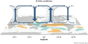
- The Walker Circulation is an atmospheric system of air flow in the equatorial Pacific Ocean. The trade winds across the tropical Pacific flow from east to west: air rises above the warm waters of the western Pacific, flows eastward at high altitudes, and descends over the eastern Pacific. A weaker Walker circulation (in the reverse direction) occurs over the Indian Ocean.
- The Walker circulation usually brings areas of high pressure to the western Indian Ocean but, in years when El Nino occurs, this pattern gets shifted eastward, bringing high pressure over India and suppressing the monsoon, especially in spring when the monsoon begins to develop.

b) Effects of El Nino and La Nina on the Indian Monsoon
- El Nino is an abnormal warming of water in the central and eastern tropical Pacific Ocean every three to five years and can last up to 18 months.
-
- An analysis of rainfall records of the past 132 years has revealed that severe droughts in India have always been accompanied by El Nino events, but not all such weather conditions have led to the failure of monsoons.
-
- La Nina is when the sea surface temperatures (SSTs) along the central and equatorial Pacific Ocean are colder than normal. During La Nina events, rainfall associated with the summer monsoon in Southeast Asia tends to be greater than normal, especially in northwest India and Bangladesh.
c) Effects of the Indian Ocean Dipole (IOD) on the Indian Monsoon
- The Indian Ocean Dipole (IOD) is defined by the difference in sea surface temperature between two areas (or poles, hence a dipole) – a western pole in the Arabian Sea (western Indian Ocean) and an eastern pole in the eastern Indian Ocean south of Indonesia.
- The positive IOD occurs when there is warmer sea surface temperature in the western Indian Ocean relative to the east. This phase of IOD is associated with greater monsoon rainfall in India and more active (above normal rainfall) monsoon days and lesser rainfall in Australia.

d) Mascarene High and Indian Monsoon
- Mascarene High is a high-pressure area that is found around Mascarene Islands (in south Indian Ocean) during monsoon period.
- The high-pressure system intensifies during the summer. This establishes a strong pressure gradient between the northern and southern hemisphere and creates a cross-equatorial wind between the two regions and a strong oceanic monsoon current over the Arabian Sea.

e) Tibetan plateau and Indian Monsoon
- As the vast Tibetan plateau, high up in the mountains, warmed during the summer months, it heated the air above, which then rose and created an area of low pressure. That belt of low pressure sucked in moisture from the oceans, thus initiating the monsoon.
- However, scientists have observed that the heating of the plateau correlated with monsoon rainfall but only during the early and late parts of the Monsoon season.
-
- The heating of the Tibetan plateau correlated well with rainfall over India from May 20 to June 15 when the monsoon was setting in. But then the correlation disappeared only to reappear again for rainfall between September 1 and October 15 when the monsoon was tailing off.
-
f) Jet Streams and Indian Monsoon

- In summer, the subtropical westerly jet stream moves north of the Himalayas with the apparent movement of the sun.
- An Easterly Jet Stream, called the sub-tropical easterly jet stream blows over peninsular India, approximately over 14-15°N during the summer months.
- This Jet Stream owes its origin to heating of Tibetan plateau due to shifting of Sun’s rays to northern hemisphere.
-
- As the vast Tibetan plateau, high up in the mountains, warmed during the summer months, it heated the air above, which then rose and created an area of low pressure. That belt of low pressure sucked in moisture from the oceans, thus initiating the monsoon.
- However, warming of the Tibetan plateau also leads to the formation of Tibetan High, a warm anticyclone (in this wind are changing in a clock-wise direction in the Northern Hemisphere and it will have always outflow of winds), located over Tibetan Plateau in the middle/upper troposphere during monsoon period.
- The outflow of winds from Tibetan High as the easterly flow concentrates into the Easterly Jet Stream.
-
- The easterly jet stream sets in along 15°N latitude only after the western jet stream has withdrawn itself from the region.
- This easterly jet stream is held responsible for the burst of the monsoon in India.
-
- Around the time of the arrival of south-west Monsoon in India, the normal rainfall increases suddenly and continues constantly for several days. This is known as the ‘burst’ of the monsoon
-
- During Break monsoon conditions Easterly Jet Stream moves northwards up to latitude 20ºN.
-
- During the south-west monsoon period after having rains for a few days, if rain fails to occur for one or more weeks, it is known as break in the monsoon.
- During the active periods of monsoon, the axis of the Tropical Easterly Jet Stream (TEJ) is located near 5ºN latitude and during break periods it is located around 15-20ºN latitude.
-
- Intensity of the Easterly Jet Stream is weak (strong) during El Nino (La Nina) events.
-
- Besides, a strong Easterly Jet Stream is associated with excess Indian Summer monsoon rainfall and vice-versa.
-
- The Easterly Jet Stream also steers the tropical depressions into India.
-
- These depressions play a significant role in the distribution of monsoon rainfall over the Indian subcontinent.
- The tracks of these depressions are the areas of highest rainfall in India.
-
- Meteorologists have found an interrelationship between the northward shift of the equatorial trough, also known as the Inter Tropical Convergence Zone (ITCZ), and the withdrawal of the westerly jet stream from over the North Indian Plain.
g) Somali Jet and Indian Monsoon
- Somali jet is low level inter-hemispheric cross equatorial flow of air along the east coast of Africa. This Jet originates near Mauritius and northern part of Madagascar in the southern Hemisphere.
- During May, it moves further into eastern Africa, then into Arabian Sea and reaches west coast of India in June. Its strengthening gives rise to strong monsoon over peninsular India.
h) Madden Julian Oscillation (MJO) and the Indian Summer Monsoon

- The Madden-Julian Oscillation (MJO) is a slow eastward movement of cloud and rainfall near the equator. It is observed mainly over the Indian and Pacific Oceans and typically recurs every 30 to 60 days.
- The MJO is characterised by wet and dry phases. A wet phase of enhanced convection (rainfall)is followed by a dry phase, where thunderstorm activity is suppressed (no rainfall). Each cycle lasts approximately 30-60 days.
- The onset of the Indian summer monsoon is often associated with the arrival of the wet phase of the tropical MJO over the Indian Ocean, while a delayed monsoon onset is likely caused by the dry phase of a strong MJO.
Characteristics of Monsoonal Rainfall
- (i) Rainfall received from the southwest monsoons is seasonal in character, which occurs between June and September.
- (ii) Monsoonal rainfall is largely governed by relief or topography. For instance the windward side of the Western Ghats register a rainfall of over 250 cm. Again, the heavy rainfall in the north-eastern states can be attributed to their hill ranges and the Eastern Himalayas.
- (iii) The monsoon rainfall has a declining trend with increasing distance from the sea. Kolkata receives 119 cm during the southwest monsoon period, Patna 105 cm, Allahabad 76 cm and Delhi 56 cm.
- (iv) The monsoon rains occur in wet spells of few days duration at a time. The wet spells are interspersed with rainless interval known as ‘breaks’.
-
- These breaks in rainfall are related to the cyclonic depressions mainly formed at the head of the Bay of Bengal, and their crossing into the mainland. Besides the frequency and intensity of these depressions, the passage followed by them determines the spatial distribution of rainfall.
-
- (v) The summer rainfall comes in a heavy downpour leading to considerable run off and soil erosion.
- (vi) Monsoons play a pivotal role in the agrarian economy of India because over three-fourths of the total rain in the country is received during the southwest monsoon season.
- (vii) Its spatial distribution is also uneven which ranges from 12 cm to more than 250 cm.
- (viii) The beginning of the rains sometimes is considerably delayed over the whole or a part of the country.
- (ix) The rains sometimes end considerably earlier than usual, causing great damage to standing crops and making the sowing of winter crops difficult.
Miscellaneous
a) What is Normal Monsoon?
- In case of monsoon season (June to September) rainfall over India as a whole, the long period average (LPA) is 87 cm (revised from 88 cm by IMD in April 2022).
-
- A monsoon is considered “normal” when rainfall falls between 96% and 104% of the LPA.
-
- Monsoon in India is considered normal when the rainfall in four Monsoon months (June – September) is 96% to 104 % of the Long Period Average (LPA) or if percentage departure of realised rainfall is within ± 10 % of the LPA.
-
- (Deficient < 90 % of LPA, Below Normal 90 – 96 % of LPA, Normal 96 -104 % of LPA, Above Normal 104 -110 % of LPA, Excess > 110 % of LPA).
-
- The ‘normal’ monsoon rains don’t imply that all months would see well distributed rains.
-
- In 2021, for instance, August stared at a 24% deficit but September, usually the month that sees the least rainfall, saw excess rains, similar to what was observed in 2019 and 2020.
-
b) Climate Change and Indian Summer Monsoon
- Temperature of the earth is increasing rapidly due to anthropogenic greenhouse gas emissions. Thermodynamically, warm air holds more moisture as compare the dry air. According to Clausius-Clapeyron equation, the capacity of air to hold moisture increases by 7% for each degree of warming. In a warmer climate, heavy rainfall events are expected to rise due to abundance of the moisture due to warming.
- Several studies have attributed the rising trend in the frequency and magnitude of the extreme rainfall events and decreasing trend in moderate rainfall events during monsoon season over central Indian region to climate change and natural variability.
- Based on recent studies it has been observed that the summer monsoon precipitation (June to September) over India has declined by around 6% from last fifty years, with notable decreases over the Indo-Gangetic Plains and the Western Ghats. It is also observed that there has been a shift in the recent period toward more frequent dry spells and more intense wet spells during the summer monsoon season.
c) What is Monsoon Mission?
- Monsoon Mission is a national programme launched by Ministry of Earth Sciences (MoES) with a vision to develop state-of-the-art dynamical prediction system for the monsoon rainfall in different time scales.
- The main objectives of this mission are:
-
- To improve Seasonal and Intra-seasonal Monsoon Forecast
- To improve Medium Range Forecast.
-
d) What is cloud burst? Can it be predicted? Which area mainly gets cloud burst?
- If 10 cm rainfall is received at a station in one hour, the rain event is termed as cloud burst.
- It is very difficult to predict the cloud bursts due to its very small scale in space and time.
- To monitor or nowcast (forecasting few hours lead time) the cloud burst, we need to have dense radar network over the cloud burst prone areas.
- Cloud bursts do occur at plains, however, mountainous regions are more prone to cloud bursts due to orography.
e) IMD Weather Apps: Mausam, Meghdoot and Damini
i) Mausam
- Mausam is a mobile app that provides all current weather forecasts through the week and even radar-based forecasts updated every 10 minutes.
- This is the first app launched by the 145-year-old India Meteorological Department (IMD), Ministry of Earth Sciences, that is meant for everyone.
ii) Meghdoot
- IMD has also launched another app, Meghdoot, meant only for farmers and those involved in agriculture.
- The Meghdoot app was developed jointly by the Digital Agriculture & Youth (DAY) team at the International Crops Research Institute for the Semi-Arid Tropics (ICRISAT) and the Indian Institute of Tropical Meteorology.
iii) Damini
- Damini Lightning Alert app, developed by the Indian Institute of Tropical Meteorology (IITM), is for giving warning to the user about the lightning on the basis of user location.
f) What is IFLOWS? How does it work?
- IFLOWS is a monitoring and flood warning system that will be able to relay alerts of possible flood-prone areas anywhere between six to 72 hours in advance.
- The primary source for the system is the amount of rainfall, but the system also factors in tidal waves and storm tides for its flood assessments.
- The system has provisions to capture the urban drainage within the city and predict the areas of flooding.
- It has been launched for Mumbai city in June 2020. It is a joint initiative between the Ministry of Earth Sciences (MoES) and Brihanmumbai Municipal Corporation (BMC). o Similar systems are being developed for Bengaluru and Kolkata.
g) Some Famous Local ‘Showers’ and Winds of Hot Weather Season:
(i) Mango Shower
- Towards the end of summer, there are pre-monsoon showers which are a common phenomena in Kerala and coastal areas of Karnataka.
- Locally, they are known as mango showers since they help in the early ripening of mangoes.
(ii) Blossom Shower
- With this shower, coffee flowers blossom in Kerala and nearby areas.
(iii) Nor Westers
- These are dreaded evening thunderstorms in Bengal and Assam.
- Their notorious nature can be understood from the local nomenclature of ‘Kalbaisakhi’, a calamity of the month of Baisakh.
- These showers are useful for tea, jute and rice cultivation.
- In Assam, these storms are known as “Bardoli Chheerha”.
(iv) Loo
- Hot, dry and oppressing winds blowing in the Northern plains from Punjab to Bihar with higher intensity between Delhi and Patna.
h) What is October Heat?
- The retreating southwest monsoon season is marked by clear skies and rise in temperature. The land is still moist. Owing to the conditions of high temperature and humidity, the weather becomes rather oppressive. This is commonly known as the ‘October Heat’.
Answer Writing Practice for UPSC Mains:
Topic: Important Geophysical Phenomena (GS Mains Paper 1)
- Write in brief the influence of the following on the Indian summer monsoon:
- a) Walker Circulation and Indian Monsoon.
- b) Effects of El Nino and La Nina on the Indian Monsoon.
- c) Effects of the Indian Ocean Dipole (IOD) on the Indian Monsoon.
- d) Tibetan plateau and Indian Monsoon. (Answer in 250 words)
References:
- NCERTs: Old and News
- https://scied.ucar.edu/learning-zone/storms/monsoons
- https://education.nationalgeographic.org/resource/monsoon/
- https://www.thehindu.com/news/national/kerala/september-holds-promise-of-an-intensified-monsoon-in-kerala/article67267225.ece
- https://www.thehindu.com/sci-tech/science/the-tibetan-plateau-and-the-indian-monsoon/article4651084.ece#:~:text=As%20the%20vast%20Tibetan%20plateau,oceans%2C%20thus%20initiating%20the%20monsoon.
- https://scijinks.gov/what-is-a-monsoon/
- https://mausam.imd.gov.in/imd_latest/monsoonfaq.pdf