Introduction
- The catastrophic landslide in Wayanad on July 30 has caused extensive devastation in Kerala, resulting in over 250 fatalities.
- This disaster is the most severe landslide-related event in Kerala’s history in terms of casualties, reigniting discussions about the Madhav Gadgil Committee (2011) and the K Kasturirangan-led High Level Working Group (2013) recommendations to designate these areas as Ecologically Sensitive Areas, which faced opposition and were never implemented.
What is a Landslide?
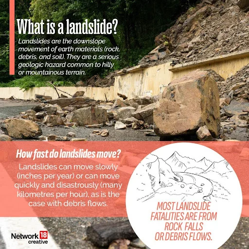
- A landslide is defined as the movement of a mass of rock, debris, or earth down a slope. Landslides are a type of “mass wasting,” which denotes any down-slope movement of soil and rock under the direct influence of gravity.
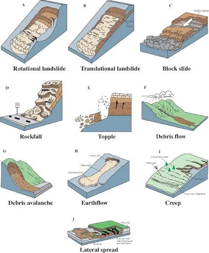
- The term “landslide” encompasses five modes of slope movement: falls, topples, slides, spreads, and flows.
- These are further subdivided by the type of geologic material (bedrock, debris, or earth). Debris flows (commonly referred to as mudflows or mudslides) and rock falls are examples of common landslide types.

Types of Landslides
- Falls: This type involves the freefall of detached pieces from a steep slope, often resulting in rockfalls.
- Example: Rock falls in the Himalayan region often block roads and create hazards for commuters, disrupting transportation and posing significant risks.
- Slides: A slide involves the downward movement of a mass of soil or rock along a defined plane.
- Example: The 2017 Munnar landslide in Kerala was a classic slide, where saturated soil slid down the slopes, causing extensive damage to homes and infrastructure.

- Flows: Flows involve the fluid movement of soil and debris, often triggered by heavy rainfall.
- Example: The 2018 Kalikhola landslide in Manipur, where heavy rains caused a debris flow that engulfed houses and farmlands, resulting in severe loss of property.
- Topples: This type involves the forward rotation of a mass around a pivot point, often leading to rock topples.
- Example: Topples are common in the Western Ghats during monsoon, where unstable rock masses fall forward, often causing road blockages and endangering lives.
See this: GS Foundation 1 Year: Structured Prep, Expert Guidance & More
How Are Landslides Classified And Mapped?
- Landslides are broadly classified based on:
- Type of materials involved (rock, debris, soil, loose mud),
- Type of movement of the material (fall, topple, slide, rotational slide or translational slide), and
- Type of flow of the material.
- Another category is of landslides that spread laterally.
- Landslides mapped in the ISRO atlas are mainly event-based and season-based.
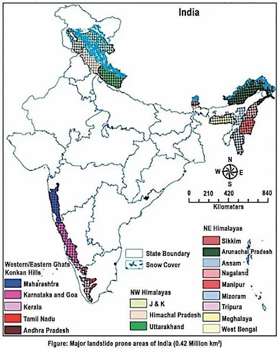
- ISRO’s National Remote Sensing Centre (NRSC), Hyderabad, has created a database of landslide-prone regions of India based on events during 1998 – 2022, primarily along the Himalayas and the Western Ghats.
- In addition to aerial images, high resolution satellite images captured using cameras Indian Remote Sensing (IRS-1D) PAN + LISS-III, satellites ResourceSat-1 and 2, etc., were used to study the landslides over the past 25 years.
- The pan-India landslide database classifies landslides into – seasonal (2014, 2017 monsoon seasons), event-based and route-based (2000 – 2017).
Factors Behind the Wayanad Landslide
- Landslides are seen as being caused by (i) conditioning factors and (ii) triggering factors.
- Conditioning Factors: are related to the soil topography, rocks, geomorphology, and slope angles, among other factors. These factors make some parts of the country more vulnerable to landslides than other parts.
- Triggering Factors: are intense rainfall, and anthropological activities such as thoughtless changes of land use, road and bridge building, haphazard and unscientific construction, and large-scale destruction of forests.
- Intense Rainfall: The region experienced significantly higher rainfall than projected by the India Meteorological Department (IMD), which led to soil saturation and increased landslide risk.
- Example: The 2018 Kerala floods witnessed unprecedented rainfall, similar to the current Wayanad situation, leading to numerous landslides across the state. The heavy rains were five times more than the India Meteorological Department’s (IMD) projections, causing severe flooding and landslides that claimed hundreds of lives.
- Chaliyar River Overflow: The heavy rainfall caused the Chaliyar River to overflow, carrying sediment downstream and stripping upstream areas of vegetation, which destabilized the soil.
- Example: In 2020, heavy rains caused the Chaliyar river to overflow, stripping upstream areas of plant cover and displacing rocks and humus. This led to increased sediment downstream, making the region more vulnerable to landslides when heavy rains occurred again in 2023.
- Soil Saturation: Continuous rainfall leads to water seeping between soil and rock layers, weakening the bonds and causing landslides.
- Example: The 2013 Uttarakhand floods, where continuous heavy rainfall saturated the soil, leading to massive landslides and the Kedarnath disaster. Water seeped between soil and rock layers, weakening the bonds and causing significant soil displacement.
- Human Activities: Quarrying, infrastructure development, and construction disturb natural land stability, increasing the risk of landslides.
- Example: The construction of the Konkan Railway, which involved extensive blasting and excavation, led to several landslides in the Western Ghats. Quarrying, infrastructure development, and construction activities have compromised the ecosystems’ ability to cope with natural changes.
- Monocropping: The replacement of native trees with shallow-rooted plantation crops like tea and coffee destabilizes soil structure.
- Example: The replacement of native trees with tea and coffee plantations in the Nilgiris has increased landslide occurrences due to the shallow roots of these crops. This agricultural practice has led to the loss of large, native trees that help hold the topsoil to the bedrock.
- Deforestation: Large-scale deforestation reduces soil stability and increases vulnerability to landslides.
- Example: Between 1950 and 2018, Wayanad lost 60% of its forests, making the area more prone to landslides. The erosion of green cover reduces soil stability, leading to increased vulnerability to landslides.
- Climate Change: Changes in climate patterns, such as the warming of the Arabian Sea, increase the intensity and frequency of rainfall.
- Example: The warming of the Arabian Sea has led to the formation of deep cloud systems, increasing rainfall in the Western Ghats. This climate change effect has been a significant factor in the increased frequency of landslides in the region.
How Prone Is India To Landslides?
- ISRO’s Landslide Atlas: India is among the top four countries at high risk for landslides, with a high loss of life per 100 km².
- India Landslide Susceptibility Map (ILSM) by IIT Madras: According to ILSM, India accounts for 8% of global landslide fatalities, with 13.17% of the country susceptible to landslides and 4.75% in the ‘very high susceptibility’ category, with Kerala being the most vulnerable state. Sikkim has the largest land area (57.6%) that is landslide-prone.

Causes of Landslides in India
Natural Causes
- Heavy Rainfall: Acts as a lubricant, loosening the material and increasing the risk of landslides.
- Example: The 2013 Uttarakhand cloudburst brought immense landslides in the region, leading to significant loss of life and property.
- Earthquakes: Create stress on slopes, causing material to flow downward, often triggering landslides in tectonically active areas.
- Example: The 2005 Kashmir earthquake triggered massive landslides, disrupting lives and causing severe damage to infrastructure and habitats.
- Nature of Rivers: Youthful rivers increase downcutting of earth on slopes, contributing to landslide risks.
- Example: The increased flow in the Chaliyar river during the Wayanad landslide led to heavy sediment erosion, worsening the situation.
Anthropogenic Causes
- Infrastructure Development: Roads, railways, and dams disturb natural slopes, increasing landslide risk.
- Example: The development of the Tehri Dam in Uttarakhand led to increased landslides in the region due to the disturbance of natural slopes and ecosystems.
- Mining Activities: Mining loosens the grip of surface material, increasing landslide susceptibility.
- Example: Extensive mining in the Western Ghats, such as bauxite mining, has led to frequent landslides due to destabilized slopes and removal of vegetation.
- Deforestation: Large-scale deforestation reduces soil stability, making areas more prone to landslides.
- Example: Deforestation in the Aravalli Range for urban development has increased landslide incidents, affecting local communities and ecosystems.
- Unsustainable Tourism: Increased tourism leads to more construction and higher landslide risks due to land pressure.
- Example: The influx of tourists in Manali has led to increased construction and subsequent landslide risks, disrupting the environment and local life.
- Climate Change: Accelerates glacial melts and increases rainfall, contributing to increased landslide frequency.
- Example: Warming of the Arabian Sea has resulted in increased rainfall in the Western Ghats, leading to enhanced landslides and environmental damage.
Impacts of Landslides in India
- Loss of Lives: Landslides cause significant loss of human and animal lives, leading to trauma and social disruption.
- Example: The Kedarnath landslide in 2013 resulted in the loss of thousands of lives and significant disruption to the local communities.
- Economic Losses: The costs of reconstruction and rehabilitation strain resources and affect development.
- Example: The 2018 Kerala floods and landslides resulted in economic losses amounting to billions of rupees, affecting the state’s economy and infrastructure.
- Infrastructural Damage: Landslides damage buildings and roads, restricting movement and connectivity.
- Example: The 2017 landslide in Munnar damaged key infrastructure, blocking roads and isolating communities, impacting daily life and commerce.
- Jeopardized Water Availability: Landslides can block rivers, affecting water supply for nearby regions.
- Example: The 2015 Nepal earthquake caused landslides that blocked rivers, creating water scarcity for nearby regions and affecting agriculture and daily needs.
- Displacement and Migration: Forced evacuation leads to social disruption and psychological stress among affected populations.
- Example: The 2010 Ladakh landslide led to the displacement of thousands of people, causing long-term social disruption and challenges in resettlement.
Government Initiatives for Landslide Mitigation
- National Landslide Susceptibility Mapping (NLSM): The Geological Survey of India initiated the NLSM program in 2014 to map landslide-prone areas on a macro scale, identifying high-risk zones.
- Example: NLSM’s mapping of Sikkim has helped identify high-risk zones, aiding in disaster preparedness and risk reduction measures.
- National Landslide Risk Management Strategy (2019): This strategy addresses all components of landslide disaster risk reduction, including hazard mapping, early warning systems, and capacity building.
- Example: This strategy has been instrumental in reducing landslide risks in vulnerable states like Himachal Pradesh through systematic planning and resource allocation.
- NDMA Guidelines on Landslide Hazard Management (2009): These guidelines propose measures for risk mitigation, including successful remediation technologies and training programs.
- Example: NDMA’s guidelines helped implement landslide risk reduction measures in the Darjeeling hills, improving resilience and preparedness.
- National Institute of Disaster Management (NIDM): NIDM provides capacity building support for disaster management, enhancing preparedness and response capabilities.
- Example: NIDM’s training programs in Uttarakhand have enhanced local preparedness for landslides, reducing the impact of disasters through effective management.
Read also: Reservations for Persons with Disabilities (PwDs) | UPSC
Challenges in Implementing Mitigation Measures
-
- Non-implementation of Committee Reports: Resistance to the Gadgil and Kasturirangan reports, which recommended stringent regulations for ecologically sensitive areas. The Gadgil Committee made several key recommendations, including:
- Zoning the Western Ghats: The report suggested dividing the Western Ghats into three zones based on ecological sensitivity:
- Ecologically Sensitive Zone 1 (ESZ1): Highly sensitive areas where almost all developmental activities should be banned.
- Ecologically Sensitive Zone 2 (ESZ2): Areas with moderate sensitivity where only limited developmental activities could be allowed under strict regulation.
- Ecologically Sensitive Zone 3 (ESZ3): Areas with lower sensitivity where regulated development could occur.
- Regulation of Developmental Activities: The committee recommended stringent regulations on mining, quarrying, and infrastructure projects. It proposed banning these activities in ESZ1 and allowing them in ESZ2 and ESZ3 under stringent guidelines.
- Promoting Sustainable Agriculture: The report suggested promoting organic farming and discouraging monocropping, which can lead to soil degradation and increased landslide risk.
- Involvement of Local Communities: The Gadgil Committee emphasized the need for involving local communities in conservation efforts and decision-making processes.
- Non-implementation of Committee Reports: Resistance to the Gadgil and Kasturirangan reports, which recommended stringent regulations for ecologically sensitive areas. The Gadgil Committee made several key recommendations, including:
- Kasturirangan Committee Report (2013): The High-Level Working Group (HLWG) on Western Ghats, led by Dr. K. Kasturirangan, was set up to review the Gadgil Committee report and address concerns raised by various stakeholders. The Kasturirangan Committee made the following recommendations:
-
-
- Demarcation of Ecologically Sensitive Areas (ESAs): The report proposed demarcating 37% of the Western Ghats as ESAs, covering around 60,000 square kilometers, which would include the most vulnerable areas.
- Regulation of Developmental Activities: The committee recommended a complete ban on mining and quarrying in the ESAs and stricter regulations on other activities such as hydroelectric projects and construction.
- Conservation and Development Balance: The Kasturirangan Committee aimed to strike a balance between environmental conservation and development needs, suggesting that certain developmental activities could continue under stringent environmental norms.
- Community Involvement: Similar to the Gadgil Committee, the Kasturirangan report emphasized involving local communities in conservation efforts and decision-making processes.
-
- Other Committees and Reports:
-
- National Forest Policy (1988): This policy aimed to increase forest cover and encourage sustainable forest management practices, indirectly contributing to landslide risk reduction by promoting afforestation and conservation of existing forests.
- Bhure Lal Committee (1999): Focused on environmental pollution control, this committee recommended stringent measures for industrial activities that could also help in mitigating landslide risks by preventing environmental degradation.
- National Action Plan on Climate Change (2008): This plan includes missions such as the National Mission for a Green India, which aims to enhance forest cover and restore degraded ecosystems, contributing to landslide risk mitigation.
- Lack of Landslide Mitigation Plans: Many states vulnerable to landslides, like Kerala, lack comprehensive plans to manage and mitigate landslide risks effectively.
- Example: The absence of a mitigation plan in Kerala led to uncoordinated responses during the Wayanad landslide, increasing the disaster’s impact.
- Insufficient Monitoring Systems: Many regions lack effective monitoring and early warning systems, increasing casualties and damage during landslides.
- Example: The lack of real-time monitoring in Arunachal Pradesh has resulted in high casualties during landslides, as timely evacuation and preparation are not possible.
- Policy and Regulatory Gaps: Weak enforcement of land-use regulations and building codes exacerbates vulnerability to landslides.
- Example: Weak building code enforcement in Himachal Pradesh has increased landslide risks in urban areas, endangering lives and property.
- Low Community Awareness: Limited public awareness and participation hinder effective disaster management and community resilience.
- Example: Low community awareness in Nagaland has hindered effective disaster management during landslides, reducing the effectiveness of response measures.
Way Forward
- Route Maps: Identify areas off-limits for settlements and map likely landslide routes to guide development and prevent disasters.
- Example: Drawing route maps in Sikkim can help guide future development away from high-risk zones, reducing vulnerability and improving safety.
- Environmental Impact Assessment: Ensure proper assessments before initiating projects to prevent ecological damage and landslides.
- Example: Rigorous EIAs in the Western Ghats can prevent large-scale ecological disruptions and landslides, protecting both the environment and communities.
- Demarcation of Ecologically Sensitive Areas: Implement recommendations for the Western Ghats to protect fragile ecosystems from overdevelopment.
- Example: Finalizing the draft notification on ecologically sensitive areas will reduce engineering projects in fragile regions, preserving biodiversity and preventing landslides.
- Landslide Micro-zoning: Adopt micro-zoning procedures for vulnerable regions to enhance precise risk mapping and prevention.
- Example: Micro-zoning in the Darjeeling hills can aid in precise landslide risk mapping and prevention, ensuring targeted and effective mitigation measures.
- Local Manpower Involvement: Engage local trained manpower for hazard reduction and awareness programs to enhance community preparedness.
- Example: Training local communities in Kerala can enhance grassroots-level preparedness and response to landslides, reducing the disaster’s impact through timely and effective action.

