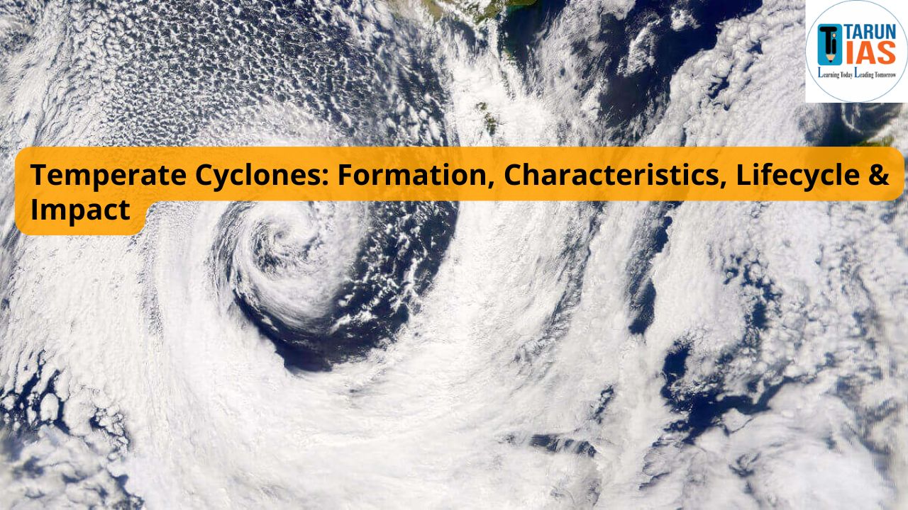
Temperate Cyclones are formed in both the hemispheres between 35-65 degree. Where the cold polar mass from the poles and warm tropical air mass collide with each other. Unlike their tropical counterparts, temperate cyclones form due to temperature contrasts between different air masses, not from warm ocean waters.

What are Temperate Cyclones?
Temperate cyclones is also known as extratropical cyclones, wave cyclones, or frontal cyclones, are large atmospheric disturbances that form in the mid and high latitudes, outside the tropical belt. These systems are associated with fronts – zones where contrasting air masses (warm and cold) meet. Their formation is tied closely to the dynamic interactions between the polar and tropical air masses.
While they lack the intense wind speeds of tropical cyclones, they influence a much larger area, bring prolonged precipitation, and can significantly alter weather patterns over continents.
Characteristics of Temperate Cyclones

Understanding the physical traits of temperate cyclones is essential for identifying their impact and forecasting their movement:
- Low Pressure Core: The system develops around a central low-pressure zone.
- Frontal System: Includes a well-defined warm front ahead and a cold front behind, with an occluded front forming during later stages.
- Large Spatial Extent: These cyclones can span between 1000 to 3000 km in diameter and reach up to 12 km in vertical height.
- Asymmetrical Structure: Often shaped like an inverted ‘V’, with distinct cold and warm sectors.
- Movement: They generally travel from west to east under the influence of prevailing westerlies.
- Seasonal Preference: Most active during late autumn, winter, and early spring, when temperature contrasts are more pronounced.
- Cloud Formation: A variety of cloud types are associated – from cirrus to cumulus – indicating different stages of cyclone evolution.
Polar Front Theory for the origin of Temperate Cyclones

The widely accepted explanation for the formation of temperate cyclones comes from the Polar Front Theory, developed by Norwegian meteorologists V. Bjerknes and J. Bjerknes.
According to this theory:
- A polar front is formed where cold, dry polar air meets warm, moist tropical air.
- This boundary becomes unstable due to temperature and pressure differences.
- The cold air tends to undercut the warm air, forcing it to rise and creating a disturbance along the front.
- Due to Earth’s rotation (Coriolis effect), this disturbance intensifies, resulting in a spiraling low-pressure system.
- As the air masses rotate and interact, a fully developed cyclone with cold and warm fronts emerges.
This process is termed cyclogenesis – the birth of a cyclone.
Lifecycle of a Temperate Cyclone

The development of a temperate cyclone follows a systematic sequence, which can be broken down into the following stages:
-
Initial (Stationary Front) Stage
-
-
- At this point, warm and cold air masses flow parallel to each other. There’s little to no mixing, and the weather remains calm.
-
-
Wave (Incipient) Stage
-
-
- A minor disturbance along the front forms a wave. Warm air begins to push northward, and cold air starts moving southward. A low-pressure area develops at the crest of the wave. This marks the beginning of cyclonic circulation.
-
-
Mature Stage
-
-
- The cyclone becomes well-organized. A distinct warm sector is sandwiched between the cold and warm fronts. Rainfall occurs along both fronts:
- Gentle precipitation ahead of the warm front due to nimbostratus clouds.
- Heavier, more localized rainfall along the cold front due to cumulonimbus clouds.
-
-
Occlusion Stage
-
-
- The cold front moves faster and eventually overtakes the warm front, lifting the warm air completely off the ground. This creates an occluded front. The cyclone starts weakening as the warm air mass – its main energy source – is cut off from the surface.
-
-
Dissipation
-
- The temperature contrast diminishes, winds die down, and the cyclone loses its organized structure. The system gradually merges with surrounding pressure zones and ceases to exist.
Weather Phenomena Associated with Temperate Cyclones
The approach and passage of a temperate cyclone bring varied weather changes. These typically follow a predictable pattern:
- Ahead of the Warm Front: High cirrus clouds, falling pressure, increasing humidity, and light drizzle.
- Within the Warm Sector: Warmer temperatures, stratus clouds, calm weather.
- Cold Front Passage: Sudden drop in temperature, sharp rainfall, gusty winds, possible thunderstorms.
- After the Cyclone: Cold, dry air, rising pressure, and clearing skies.
Temperate Cyclones and Western Disturbances of India

In the Indian subcontinent, temperate cyclones manifest as western disturbances – a term that holds great significance in the context of India’s winter weather patterns. Although often less discussed in mainstream discourse, these systems are important for agriculture, water management, and seasonal climate regulation, especially in northern India.
What are Western Disturbances?
- Western Disturbances are low-pressure systems that originate in the Mediterranean region. Driven by the westerly jet streams, they travel eastwards across Central Asia and enter the Indian subcontinent, especially during the winter and early spring months. By the time they reach India, their energy has often reorganized due to interactions with the local topography, particularly the Himalayas.
- Upon reaching the northwestern parts of India, these disturbances bring along moisture-laden winds, which interact with the western Himalayas and the Indo-Gangetic plains, resulting in rainfall and snowfall.
Areas Affected in India by Temperate Cyclones
The primary impact zones of Western Disturbances include Jammu & Kashmir, Himachal Pradesh, Punjab, Haryana, Rajasthan, and parts of western Uttar Pradesh. Their arrival between December and April is well-timed with the region’s rabi crop cycle, especially for wheat and mustard.
Temperate Cyclones Role in India’s Climatic and Agricultural Landscape
Positive Contributions
Temperate cyclones bring winter rainfall to northwestern India, supporting rabi crops and maintaining climatic balance in arid regions.
- Winter Precipitation:
- Western Disturbances are responsible for the bulk of winter rainfall and snowfall in north and northwestern India. This is crucial in a season otherwise marked by dry conditions.
- Support for Rabi Crops:
- These systems provide much-needed moisture for the successful cultivation of wheat, which is the backbone of India’s rabi season. Without this natural irrigation, yields could suffer significantly, especially in unirrigated areas.
- Water Resource Recharge:
- The rainfall associated with these cyclones plays a pivotal role in replenishing surface water bodies and improving groundwater levels, especially in states like Punjab and Haryana, where agricultural dependence on water is high.
- Moderation of Winter Temperatures:
- Cloud cover and precipitation from Western Disturbances can help in raising minimum temperatures, reducing the severity of cold wave conditions, particularly in the plains.
Associated Challenges of Temperate Cyclones
Despite their benefits, Western Disturbances can also bring challenges, especially when their timing or intensity deviates from the norm.
- Excess Rainfall and Flooding:
- Sometimes, these disturbances lead to unseasonal and excessive rainfall, triggering flash floods in hilly regions and waterlogging in plains. This disrupts daily life and causes damage to standing crops.
- Disruptions in Transport and Visibility:
- The moisture brought by these systems often results in dense fog formation, which hampers road, rail, and air transport. Visibility issues are common in the Indo-Gangetic plains during peak winter months.
- Adverse Impact on Agriculture:
- If Western Disturbances strike at the wrong stage of crop growth, especially during flowering or harvesting, they can lead to crop damage, pest outbreaks, or fungal infections, thereby impacting farmers’ incomes.
Temperate vs Tropical Cyclones: A Comparative Overview
Temperate cyclones form in mid-latitudes with fronts, while tropical cyclones develop over warm oceans with intense low-pressure systems.
| Feature | Temperate Cyclones | Tropical Cyclones |
| Location | 35°–65° latitudes | 5°–30° latitudes (tropics) |
| Formation Area | Land and sea | Only over warm ocean waters |
| Fronts Involved | Yes (cold, warm, occluded) | No fronts involved |
| Energy Source | Temperature contrast between air masses | Latent heat from ocean evaporation |
| Size | 1000–3000 km | 500–1000 km |
| Duration | 5–15 days | 5–7 days |
| Movement | West to east (with westerlies) | East to west (with trade winds) |
| Wind Speed | Moderate (30–70 kmph) | Very high (up to 300 kmph) |
| Rainfall Pattern | Widespread, prolonged | Intense and concentrated |
| Impact in India | Winter rain (North-West) | Monsoon, coastal storms (East/South coast) |
Distribution of Temperate Cyclones Across the Globe

These cyclones are prominent across various mid-latitude regions:
- North America: Colorado low, Alberta clipper systems, Great Lakes depressions.
- Europe: Icelandic low, North Atlantic storm tracks.
- Russia & Siberia: Persistent winter depressions.
- Mediterranean Basin: Source region for Western Disturbances.
- Southern Hemisphere: Southern Ocean near Antarctica, New Zealand, South Atlantic depressions.
Cyclone Structure and Dynamics of Temperate Cyclones
A well-developed temperate cyclone consists of:
- Cold Sector: Located behind the cold front, dominated by dry, descending air.
- Warm Sector: Between the two fronts, this area has rising, warm moist air causing cloudiness and rain.
- Cloud Types:
- Cirrus and cirrostratus ahead of the warm front.
- Nimbostratus along the warm front.
- Cumulonimbus and cumulus along the cold front.
As a cyclone evolves, these clouds and rainfall zones shift accordingly, providing key indicators for weather prediction.
Influence of Jet Streams and Rossby Waves of Temperate Cyclones
Jet streams – narrow, fast-moving air currents in the upper troposphere – play a vital role in guiding and intensifying temperate cyclones. Their oscillations, known as Rossby waves, often lead to the creation of waves along the polar front, initiating cyclone formation.
When these waves deepen, the associated surface low-pressure systems intensify, forming large cyclonic storms. These jet stream paths are also critical for forecasting the direction and speed of cyclone movement.
Associated Anticyclones of Temperate Cyclones
Temperate cyclones are typically followed or accompanied by anticyclones – high-pressure systems where air descends and circulates outward.
- These systems bring clear skies and stable weather.
- The alternation of cyclones and anticyclones regulates weather over the mid-latitudes.
Cyclone Management and Preparedness in India Tackling the Impacts of Western Disturbances
Though less violent than their tropical counterparts, temperate cyclones, particularly Western Disturbances, still pose significant challenges in India—ranging from unexpected rainfall and floods to transportation bottlenecks and agricultural losses. Therefore, a structured and scientific approach to management and preparedness is essential to minimize their adverse impacts and leverage their benefits.
Understanding the Risk Profile
- Western Disturbances are not typically associated with high-velocity winds or catastrophic destruction. However, their slow-moving nature, coupled with their ability to trigger persistent rainfall, snowfall, flash floods, and dense fog, makes them a high-impact, low-visibility threat.
- This is particularly evident in winter months across North and North-West India, where these disturbances can disrupt both urban infrastructure and rural livelihoods.
Key Strategies for Effective Cyclone Management
Advanced Weather Forecasting and Early Warning Systems
-
- The foundation of any disaster management strategy is accurate and timely forecasting. India has made significant strides in this direction with the integration of:
- Satellite imagery (INSAT series)
- Doppler Weather Radars (DWRs)
- Numerical Weather Prediction (NWP) models
- These tools enable meteorological agencies like the India Meteorological Department (IMD) to detect and track Western Disturbances as they form over the Mediterranean and approach India.
- Early alerts issued to farmers, district administrations, and transport agencies through mobile apps, TV, radio, and community networks play a vital role in reducing risk.
Climate-Smart Agricultural Planning
- Since Western Disturbances directly influence rabi crop cycles, especially wheat, mustard, and barley, agricultural strategies must align with seasonal forecasts. Key interventions include:
- Adjusting sowing and harvesting schedules to avoid peak disturbance periods.
- Promoting weather-based crop insurance schemes to buffer financial losses.
- Encouraging water-efficient irrigation practices post-precipitation to prevent waterlogging.
- Krishi Vigyan Kendras (KVKs) and State Agricultural Universities play a pivotal role in disseminating this guidance to farmers on the ground.
Infrastructure Resilience and Urban Preparedness
- To deal with urban flooding and fog-related transport issues, planners must prioritize climate-resilient infrastructure, especially in vulnerable zones. Recommended measures include:
- Upgrading drainage systems in cities and towns to handle short bursts of heavy rainfall.
- Constructing flood barriers and retention basins in flood-prone plains.
- Improving road quality, visibility markers, and fog-light systems on highways and rail networks.
- Moreover, airport authorities and railway management systems need dynamic scheduling and rerouting mechanisms during periods of reduced visibility.
Public Awareness and Multi-Stakeholder Coordination
- Timely information dissemination is as crucial as technical preparedness. A well-informed public is better equipped to respond to changing weather conditions. Focus areas include:
- Issuing area-specific advisories to farmers about rainfall, pests, and cold stress.
- Alerting transport agencies about fog and waterlogging risks.
- Guiding emergency services on rescue routes and flood-prone zones.
- Community-based disaster response systems, school-level awareness campaigns, and collaboration between State Disaster Response Forces (SDRFs) and local governance bodies ensure a more grounded response.
Conclusion
Temperate cyclones are vital drivers of weather dynamics in the mid-latitudes. Their formation is a testament to nature’s complexity – shaped by temperature gradients, upper air circulation, and Earth’s rotation. In India, they arrive as Western Disturbances and influence agriculture, water availability, and even regional climate trends.
Understanding their lifecycle – from genesis at the polar front to eventual dissipation – not only enhances our knowledge of climatology but also strengthens disaster preparedness.