Basic Concepts
River: A continuous body of water that flows downhill under the influence of gravity.
- Source: The origin point where a river begins, often referred to as its headwaters.
- Mouth: The location where a river empties into another large body of water, such as a larger river, sea, or ocean.
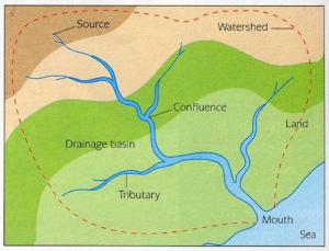
- Tributary: A smaller stream or river that feeds into a larger river.
- Confluence: The point where two rivers meet.
- Distributary: A branch of a river that diverges from the main river and does not rejoin it. For instance, the Bhagirathi and Hooghly are distributaries of the Ganga.
- Drainage Basin: The region where all precipitation drains into a particular river or a network of rivers, also known as a catchment area.
- Watershed: The boundary that separates adjacent drainage basins; it is essentially a smaller drainage basin.
Types of Drainage Systems
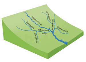
Drainage systems are divided into two main categories: Sequent and Insequent systems.
- Sequent Drainage System: Rivers that follow the natural slope of the land.
- Insequent Drainage System: Rivers that do not follow the land’s natural slope and do not align with the geological structure.
|
Sequent Drainage System |
|
|
|
|
|
|
|
|
Insequent Drainage System |
Antecedent Drainage System: Rivers that existed before the land uplift. Example: Indus, Sutlej, Brahmaputra. |
| Superimposed Drainage System: Streams that do not follow the underlying rock structure, having been created over rocks that have since been eroded. Example: Damodar, Subarnarekha, Chambal, Banas. |
Drainage Patterns
These are the various shapes formed by a river and its tributaries across the drainage basin.
- Dendritic Drainage: A tree-like pattern formed by rivers and their tributaries.
Example: Indus, Mahanadi, Godavari. - Trellised Drainage: Primary tributaries run parallel, and secondary ones join at right angles.
Example: River Seine (France). - Rectangular Drainage: Tributaries meet the main river at steep angles.
Example: Chambal, Betwa, Ken. - Radial Drainage: Formed when a river flows outward from a central elevated region.
Example: South Koel, Subarnarekha, Kanchi, Karo. - Centripetal Drainage: Streams converge towards a central depression.
Example: Lower Chambal Basin.
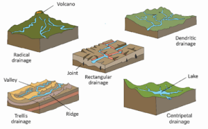
- Annular/Circular Drainage: Formed by tributaries arranged in a circular shape.
Example: Sonapet dome in Uttarakhand. - Parallel Drainage: Tributaries run parallel to each other, following the natural slope of the land.
Example: Rivers flowing from the Western Ghats into the Arabian Sea. - Barbed Drainage: Tributaries flow in the opposite direction to the main river.
Example: Arun River. - Pinnate Drainage: Resembling the veins of a leaf, formed in narrow valleys surrounded by steep slopes.
Example: Son and Narmada.
The Course of a River
River Course and Erosion Processes
- Corrasion (Abrasion): The action of solid materials, like boulders, carried by the river scraping and wearing down the valley walls.
- Solution (Corrosion): The dissolving of soluble materials from rocks like carbonate rocks through chemical processes.
- Hydraulic Action: The breakdown of rocks due to the direct impact of water.
- Attrition: The grinding and collision of rocks against each other, breaking them into smaller pieces.
Erosional Landforms
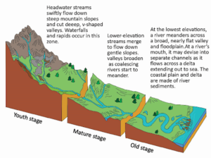
River Valleys: Extended depressions where rivers flow. The shape of valleys changes with the erosion stage.
- Youth Stage: Steep, narrow valleys formed by vertical erosion.
- Mature Stage: Broader, “U” shaped valleys from lateral erosion.
- Gorges: Narrow valleys with steep, rocky walls.
Example: Kali Gandaki Gorge. - Canyons: A type of gorge, broader at the top than at the base.
Example: Grand Canyon in Arizona. - Waterfalls: Sudden drops of water from a height, often creating pools below.
Example: Niagara Falls and Victoria Falls. - Rapids: Smaller waterfalls formed in areas where rivers flow over uneven rock resistance.
- Potholes and Plunge Pools: Circular depressions in rocky riverbeds, often forming at the base of waterfalls.
- River Terraces: Flat surfaces along the valley floor that indicate former floodplain levels.
- Paired Terraces: Equal elevation on both sides of th
 e river.
 - Unpaired Terraces: Found on one side of the river only, or at varying heights.
- Paired Terraces: Equal elevation on both sides of th
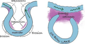
- River Meanders: Curves in the river formed due to erosion on the outer bank and deposition on the inner bank.
- Ox-Bow Lakes: Formed when a meander is abandoned, creating a lake in the old loop.
Example: Kanwar Lake in Bihar.
|
River Transportation
Rivers transport materials in the following ways:
- Traction: Large rocks roll, slide, or bounce along the riverbed.
- Saltation: Medium-sized particles move along the riverbed in jumps.
- Suspension: Small particles like sand and silt are carried by the flowing water.
- Solution: Soluble materials dissolve in the water and are carried along.
Depositional Landforms
Alluvial Fans and Cones: Sediments deposited by rivers as they move from narrow mountain valleys to plains, forming fan- or cone-shaped deposits.
- Flood Plains: Flat, sloping land beside rivers, formed by sedimentary deposits.
- Natural Levees: Ridges formed by sediment deposition along riverbanks.
- Point Bars: Sediments deposited on the inner bank of river bends.
- Deltas: Triangular or fan-shaped features formed at river mouths due to sediment deposition.
Types of Deltas
- Arcuate Delta: Shaped like an arc.
Example: Nile Delta, Ganga Delta. - Bird-foot Delta: Resembling a bird’s foot.
Example: Mississippi Delta. - Estuarine Delta: Formed in submerged river mouths (estuaries).
Example: Narmada and Tapi deltas. - Cuspate Delta: Formed where sediment collisions create uneven distribution.
Example: Tiber River Delta.
|
||||||||||