Earthquakes Causes Introduction
- A very powerful magnitude 8.8 earthquake off Russia’s Far Eastern Kamchatka coast recently triggered tsunami warnings as far away as French Polynesia and Chile, and was followed by an eruption of the most active volcano on the peninsula.
- The shallow quake damaged buildings and injured several people in the remote Russian region, while much of Japan’s eastern seaboard – devastated by a 9.0 magnitude earthquake and tsunami in 2011 – was ordered to evacuate, as were parts of Hawaii.
What are Earthquakes?
- An earthquake (also referred to as a quake, tremor, or temblor) is a natural phenomenon characterized by the shaking of the Earth’s surface.
- This seismic event is caused by the sudden release of energy within the Earth’s lithosphere, resulting in the creation of seismic waves that propagate throughout the planet.
- Earthquakes can vary in intensity, and understanding their underlying causes is crucial for assessing risk and preparedness.
What Causes an Earthquake?
- Earthquakes are a type of diastrophic movement—a term used to describe large-scale deformations of the Earth’s crust. The main driver of an earthquake is the release of accumulated energy along faults in the Earth’s crust.
- A fault is a fracture or break in the Earth’s crust where two blocks of rock have moved relative to each other. Over time, these blocks can become locked together due to friction, preventing them from moving freely.
- As tectonic forces continue to press on these locked rocks, the stress builds up until it overcomes the friction. When this happens, the rocks suddenly slip or slide past each other, resulting in the release of energy. This release of energy causes the seismic waves that we feel as an earthquake.
The Key Points: Focus and Epicenter
- The point where the energy is initially released is called the focus or hypocenter. This is located beneath the Earth’s surface, within the lithosphere, and is the origin of the earthquake. The focus is where the rocks finally break and move, causing the release of stored energy.
- The epicenter, on the other hand, is the point on the Earth’s surface that is directly above the focus. It is usually the area that experiences the most intense shaking, as it lies closest to where the earthquake’s energy first emerged. The intensity of shaking decreases as you move away from the epicenter.
The Science of Seismic Waves
- Once the energy is released at the focus, seismic waves travel in all directions. These waves can be classified into several types, including P-waves (primary or compressional waves), S-waves (secondary or shear waves), and surface waves.
- Each of these waves moves through the Earth in different ways, and the speed at which they travel and the way they shake the ground can be measured to determine the location and magnitude of the earthquake.
- Earthquakes are among the most powerful natural events, with their strength measured by both magnitude and intensity. While magnitude indicates the energy released by the earthquake, intensity refers to how the shaking is perceived at specific locations.
- To measure seismic activity, a seismograph is used. This instrument tracks the relative motion between the Earth’s surface and a suspended mass, recording the intensity and duration of the seismic waves. The seismograph captures P-waves (primary waves), S-waves (secondary waves), and surface waves, which travel at different speeds and cause varying degrees of shaking.
What are Different Types of Earthquakes?
- Shallow-Focus Earthquakes:
-
-
- Depth: 0 – 70 km
- Occurrence: These are the most common type of earthquakes, accounting for around 80% of all seismic events.
- Impact: Shallow-focus earthquakes are the most destructive because they occur near the Earth’s surface, meaning the energy released travels a shorter distance and causes more intense shaking. These earthquakes often lead to widespread damage in populated areas. Examples:
- Nepal earthquake (2015): A devastating earthquake that struck Nepal and surrounding regions, causing massive destruction and loss of life.
- Bhuj earthquake (2001): This earthquake hit the Gujarat region in India, causing significant damage to infrastructure and loss of life.
-
- Intermediate-Focus Earthquakes:
-
-
- Depth: 70 – 300 km
- Occurrence: Around 12% of all earthquakes are intermediate-focus.
- Impact: These earthquakes are less destructive than shallow-focus earthquakes, but they can still cause significant damage over a large area. Due to their moderate depth, the energy from intermediate-focus quakes can travel over long distances, shaking regions far from the epicenter. Examples:
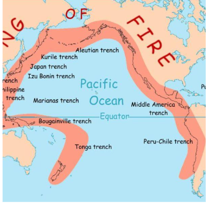
- Earthquakes in subduction zones, such as those along the Peru-Chile Trench, where oceanic plates are forced beneath continental plates, generating moderate but widespread seismic activity.
-
- Deep-Focus Earthquakes
-
- Depth: 300 – 700 km
- Occurrence: Only around 3% of all earthquakes fall into the deep-focus category.
Impact: Deep-focus earthquakes rarely cause surface destruction due to their great depth. However, they can be extremely powerful and are often felt over vast distances. Their energy release is typically concentrated deep within the Earth, meaning the shaking is less intense at the surface, but the magnitude can be immense. Examples: - Tonga Trench: Earthquakes occurring in this region, part of the Pacific Ocean’s Ring of Fire, are some of the most significant deep-focus events.
- Mariana Trench: The world’s deepest oceanic trench also experiences deep-focus earthquakes, generating seismic waves that travel across large portions of the globe.
Distribution of Earthquakes: Key Seismic Zones Around the World
-
- Earthquakes are not randomly distributed across the planet; rather, they occur in specific regions known as seismic belts. These belts are primarily concentrated along plate boundaries where tectonic forces cause stress and movement. Understanding the distribution of earthquakes helps us to identify high-risk zones and improve preparedness. Here are the major earthquake-prone regions:
- Circum-Pacific Belt (Ring of Fire):
-
-
- Location: Surrounds the Pacific Ocean, including countries like Japan, Indonesia, the Philippines, Chile, Alaska, and California.
- Share of Global Earthquakes: ~70–80% of the world’s earthquakes occur in this region.
- Cause: The primary cause of earthquakes in the Ring of Fire is subduction zones (where one tectonic plate is forced under another) and transform faults (where plates slide past each other).
- Characteristics: This belt is the most active seismic zone globally, with frequent, powerful earthquakes and volcanic activity. It is also home to numerous volcanoes and deep ocean trenches.
-
- Alpine–Himalayan Belt:
-
-
- Location: Stretches from the Mediterranean, across the Middle East, through the Himalayas, and down to Southeast Asia.
- Share of Global Earthquakes: 15–20% of the world’s earthquakes occur here.
Cause: The region experiences intense seismic activity due to the collision of the Eurasian Plate with the African Plate and the Indian Plate. This collision results in the formation of mountain ranges, such as the Himalayas, and the release of stress along fault lines, leading to earthquakes. - Characteristics: This region is highly tectonically active, with large, destructive earthquakes, especially in areas like Nepal, Pakistan, and Turkey.
-
- Mid-Atlantic Ridge (Oceanic Ridges):
-
-
- Location: Runs through the Atlantic Ocean, with notable features like Iceland located along this ridge.
- Cause: The seismic activity here is primarily caused by divergent plate boundaries, where tectonic plates are moving apart due to sea-floor spreading.
Earthquake Type: Mostly shallow-focus earthquakes occur along these ridges, as the plates are slowly being pulled apart. - Characteristics: Earthquakes along the Mid-Atlantic Ridge tend to be less destructive than those in other seismic zones, but they still play a significant role in global seismic activity.
-
- Intraplate Earthquakes:
-
- Location: These earthquakes occur within tectonic plates, far from the boundaries where most seismic activity takes place. Examples:
- New Madrid Seismic Zone (USA): This area in the central United States has experienced significant intraplate earthquakes in the past, including a series of large quakes in 1811–1812.
- Kutch Region (India): Located in the western part of India, this region also experiences intraplate seismic activity, notably the Bhuj earthquake of 2001.
Cause: These earthquakes are caused by stress accumulation within the tectonic plates, away from plate boundaries. Although less frequent, intraplate earthquakes can still be powerful and damaging. - Characteristics: The seismic activity here tends to be more unpredictable, as it occurs far from traditional fault lines.
Kamchatka: A High-Risk Seismic Zone
-
- The Kamchatka Peninsula, located in Russia’s Far East, is recognized as one of the world’s most earthquake-prone regions. This area, stretching over 1,250 kilometers, has experienced numerous powerful seismic events throughout its history.
- The region’s unique tectonic setting contributes to its vulnerability to frequent and sometimes devastating earthquakes, some of which have been strong enough to trigger deadly tsunamis. Let’s explore why Kamchatka is considered a high-risk seismic zone and look at the history of major earthquakes in this area.
- Kamchatka: A Seismic Hotspot
-
-
- The Kamchatka Peninsula is situated at the boundary of the Pacific Plate and the Eurasian Plate, making it part of the Ring of Fire, the world’s most active earthquake and volcano zone.
-
- Major Earthquakes in Kamchatka’s History
-
- Kamchatka’s seismic history is marked by several powerful earthquakes that have caused widespread damage and, in some cases, triggered tsunamis. Some of the most notable earthquakes include:
- 2020 Earthquake: Kamchatka witnessed a magnitude 7.5 earthquake in 2020, which prompted tsunami warnings in the region. While no major damage was reported, it underscored the ongoing seismic threat to the area.
- 2006 Earthquake: Another significant earthquake struck Kamchatka in 2006, with a magnitude of 7.7. This earthquake was felt across the region and led to a substantial number of aftershocks.
- 1959 and 1952 Earthquakes: Kamchatka experienced large earthquakes in 1959 and 1952 that caused significant damage and were followed by deadly tsunamis. These events are a reminder of the region’s vulnerability to both seismic shocks and the subsequent tsunami risk.
- 1923 Earthquake: In 1923, Kamchatka endured a magnitude 8.3 earthquake, which caused widespread destruction and triggered a devastating tsunami. The event left a lasting mark on the region’s history.
- Historical Earthquakes: A Long-Standing Threat
-
-
- Beyond recent events, Kamchatka has a long history of seismic activity. Historical records mention significant earthquakes as far back as 1841 and 1737, indicating that this region has been a seismic hotspot for centuries. The frequency of these events highlights the ongoing geological activity beneath the peninsula.
-
- Kamchatka’s Vulnerability to Tsunamis
-
- In addition to the earthquakes, Kamchatka is highly vulnerable to tsunamis, which are often triggered by seismic events.
- The region lies near subduction zones, where one tectonic plate is forced beneath another.
- This process frequently generates underwater earthquakes that can displace large volumes of water, leading to devastating tsunamis that affect the coastal areas of Kamchatka and nearby regions.
Frequent Earthquakes Driven by Tectonic Plate Movements: The Role of Subduction Zones
- Subduction: A Primary Driver of Seismic Activity: Subduction is a geological process where one tectonic plate slides beneath another. In the case of Kamchatka and surrounding regions, the Pacific Plate, which is denser, sinks beneath the Okhotsk microplate, a lighter plate. This plate interaction creates significant stress at the plate boundaries, which is gradually released in the form of earthquakes. The constant movement and interaction of these plates cause ongoing seismic activity in the region.
- The Stress-Building Process and Earthquake Generation: As the Pacific Plate sinks beneath the Okhotsk microplate, stress accumulates over time along the boundary between the plates. This accumulated tension eventually overcomes the friction that holds the plates together, resulting in the sudden release of energy, which is manifested as an earthquake. The release of energy can also trigger tsunamis, especially in the North Pacific, where the subduction zones are active.
- A Parallel with the Himalayas: Subduction and Mountain Formation: Subduction also plays a significant role in the formation of mountain ranges. For example, the Himalayas were formed by the Indian Plate pushing beneath the Eurasian Plate through subduction, making this region highly earthquake-prone. Similar processes in the Kuril-Kamchatka Trench also result in significant seismic activity, including massive earthquakes and tsunamis in the surrounding areas.
- The Kuril-Kamchatka Trench: A Seismic Hotspot: The Kuril-Kamchatka Trench is a prominent geological feature where the subduction of the Pacific Plate occurs. This trench reaches depths of nearly 10 kilometers, making it one of the most significant subduction zones in the world. The ongoing subduction process in this region causes the Pacific Plate to descend at a rate of approximately 86 mm per year, leading to the buildup of substantial tectonic stress. This stress is periodically released in the form of large earthquakes and tsunamis, posing a constant threat to the region.
- Earthquake and Tsunami Generation: A Global Threat: The megathrust fault along the subduction zone of the Kuril-Kamchatka Trench is particularly prone to generating powerful earthquakes. These earthquakes can trigger tsunamis, which travel across the North Pacific, affecting coastal regions far beyond the earthquake’s epicenter. The frequency of these events underscores the significant seismic risk posed by the tectonic movements in this region.