This is a ‘calendar’ that records the events that have occurred in Earth’s history. It breaks down the time into eons, eras, periods, epochs and ages; the first being the longest time frame and the last being the smallest.
| ERA | YEARS IN MILLION | PERIOD | EPOCH | FAUNA | FLORA |
| Cenozoic | 1 | Quaternary | Recent
(Holocene) |
Age of mammals | Angiosperms Monocotyledons |
| 6 | Pleistocene | Age of Human Being | Age of Angiosperms – Dicotyledons | ||
| 10 | Tertiary | Pliocene | Human Evolution | ||
| 15 | Miocene | Mammals and birds | |||
| 20 | Oligocene | ||||
| 100 | Eocene | ||||
| Palaeocene | |||||
| Mesozoic | 125 | Cretaceous | (Golden age of Reptiles)
Rise of Danseurs |
Sphenopsids, Ginkgos, Gnetales, (Dicotyledons) | |
| 150 | Jurassic | Herbaceous lycopods, Ferns, Conifers, Cycads | |||
| 180 | Triassic | ||||
| Paleozoic | 205 | Permian | Mammal like reptiles | Arborescent lycopods | |
| 230 | Carboniferous | Pennsylvania | Earliest Reptiles | Seed ferns and Bryophytes | |
| 255 | Mississippian | Earliest Amphibians and abundant Echinoderms | |||
| 315 | Devonian | Age of fishes | Progymnosperms | ||
| 350 | Silurian | Earliest fishes and land invertebrates | Zosterophyllum | ||
| 430 | Ordovician | Dominance of invertebrates | Appearance of first land plants | ||
| 510 | Cambrian | Fossil invertebrates | Origin of algae | ||
| Precambrian | 3000 | Upper | Multicellular organisms | ||
| Middle | Appearance of eukaryotes | ||||
| Lower | Planktons prokaryotes |
Geographical Grid, Latitude and Longitude
The geographical grid is a network of imaginary lines drawn across the Earth’s surface, designed to pinpoint exact locations using coordinates.
Latitude
- Definition: Latitude represents the angular distance of a location north or south of the Equator.
- Measurement: It is determined using 180 horizontal imaginary lines called parallels.
- Key Features:
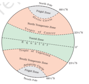
- Equator:
- It is the 0° latitude line.
- The Equator divides the Earth into the Northern and Southern Hemispheres, making it the largest circle on the globe, also referred to as the “Great Circle.”
- Poles:
- The North Pole is at 90° North latitude whereas the South Pole is at 90° South latitude.
- Equator:
- Tropics: These are geographic areas that check the northernmost and southernmost latitudes where the sun can be seen directly overhead during a solstice.
- Tropic of Cancer: It is located approximately at 23.5° north of the equator.
- Tropic of Capricorn: It is found at approximately 23.5° south of the equator.
- Arctic Circle: Arctic Circle: The Arctic Circle is a line of latitude located around 66.5 degrees north of the Earth’s equator.
- Antarctic Circle: It is a parallel of latitude on the Earth at approximately 66.5 degrees south of the equator.
| Equator passes through the following Countries | Tropic of Cancer passes through the following Countries | Tropic of Capricorn passes through the following Countries |
| Colombia, Brazil, São Tomé & Principe, Ecuador, Gabon, Republic of the Congo, Kenya, Democratic Republic of the Congo, Uganda, Somalia, Maldives, Indonesia and Kiribati. | Algeria, Niger, Libya, Egypt, Saudi Arabia, United Arab Emirates, Oman, India, Bangladesh, Myanmar, China, Taiwan, Mexico, Bahamas, Mauritania and Mali | Namibia, Botswana, South Africa, Mozambique, Madagascar, Australia, Chile, Argentina, Paraguay, and Brazil. |
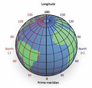
Longitude
- Longitude refers to the angular measurement that indicates a location’s position east or west of the Prime Meridian.
- It is determined using imaginary vertical lines, called meridians, which encircle the Earth and converge at the North and South Poles.
- The widest spacing of these meridians occurs near the Equator, where the Earth has its greatest circumference.
- All meridians converge at the poles.
- The Prime Meridian, which passes through Greenwich, England, is universally recognized as the reference line for 0 degrees longitude.
- This meridian serves as the standard for calculating time, with the time measured at this line known as Greenwich Mean Time (GMT).
| Countries through which Prime Meridian passes: England, France, Spain, Algeria, Mali, Burkina Faso, Togo, Ghana and Antarctica. |
- Eastern and Western Hemispheres: These are the two halves into which the Earth is divided.
- The Eastern Hemisphere includes all areas located east of the Prime Meridian, measured in degrees east.
- Similarly, the Western Hemisphere encompasses regions west of the Prime Meridian, measured in degrees west.
International Date Line
- The place where the day begins is called the Worldwide Date Line.
- The line is a hypothetical one that extends from the North Pole to the South Pole, traversing through the central Pacific Ocean.
- It roughly follows the 180° longitude meridian. There are 24 standardized time zones, one for each hour of the earth’s rotation.
Daylight Saving Time
- It is the practice of advancing clocks in summer months by one hour.
- Countries where practised: USA, Canada, European Union Countries, Argentina, Cuba, etc.
Different Motions of the Earth
Rotation
-
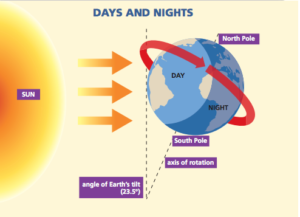
- The Earth’s rotation refers to its spinning motion around its axis.
- The earth spins counterclockwise.
- To complete one rotation on its axis, the earth takes approximately 23 hours, 56 minutes, and 4 seconds.
- The duration of Earth’s rotation is referred to as a day or an Earth day.
- The circle that separates the day from the night is called the circle of illumination.
- Significance of Earth’s Rotation
-
- Responsible for the alternation of day and night, influencing variations in temperature, light, and humidity.
- Plays a crucial role in driving oceanic water movement, contributing to currents and other marine dynamics.
- Responsible for deflection of tides.
- Responsible for the general circulation in the earth’s atmosphere.
- Earth’s rotation causes the deflection of wind and ocean currents. In the Northern Hemisphere, these currents are deflected to the right, while in the Southern Hemisphere, they are deflected to the left. This phenomenon is a result of the Coriolis effect.
PYQ. Variations in the length of daytime and night times from season to season are due to (2013)
Answer: D |
Revolution
- Definition: Revolution refers to Earth’s movement around the Sun along its elliptical orbit. This journey takes approximately 365 days, 6 hours, and 9 minutes to complete, forming what is known as a year.
- Leap Year: A year with 366 days, occurring every four years, is called a leap year.
Significance of Earth’s Revolution
- Earth’s revolution is responsible for the occurrence of seasons.
- It also leads to the phenomena of aphelion and perihelion:
- Aphelion: On July 4th, Earth is farthest from the Sun at a distance of 152 million km. This position is known as aphelion.
- Perihelion: On January 3rd, Earth is closest to the Sun at a distance of 147 million km. This position is called perihelion.
Axis of the Earth
- The Earth’s axis is an imaginary line passing through its center, connecting the North Pole to the South Pole.
- It is tilted at an angle of 23.5° from the vertical or 66.5° relative to the orbital plane (the plane of Earth’s orbit).
Polar Motion
- Definition: Polar motion refers to the movement of Earth’s rotational axis relative to its surface. It is influenced by changes in the planet’s mass distribution.
- Factors:
- Cyclic or Seasonal: For example, variations in atmospheric and oceanic mass distribution cause seasonal polar motion.
- One-directional: Melting of large ice sheets is an example of non-cyclic, directional polar motion.
Seasons of Earth: How Revolution Shapes Climate Across Hemispheres
Earth experiences four main seasons: summer, winter, spring, and autumn. The changing position of Earth during its revolution around the Sun causes the seasons.
| Months | Northern Hemisphere | Southern Hemisphere |
|---|---|---|
| June to August | – Direct sunlight, warmer temperatures (summer). | – Oblique sunlight, cooler temperatures (winter). |
| – Continuous daylight beyond the Arctic Circle. | – Continuous night beyond the Antarctic Circle. | |
| December to February | – Oblique sunlight, cooler temperatures (winter). | – Direct sunlight, warmer temperatures (summer). |
| – Continuous night beyond the Arctic Circle. | – Continuous daylight beyond the Antarctic Circle. | |
| September to November | – Equal sunlight for both hemispheres (autumn). | – Equal sunlight for both hemispheres (spring). |
| March to May | – Equal sunlight for both hemispheres (spring). | – Equal sunlight for both hemispheres (autumn). |
Solstices and Equinoxes
Summer Solstice (June 21)
- The Sun is directly overhead the Tropic of Cancer.
- The Northern Hemisphere experiences its longest day, and the Arctic Circle has 24-hour daylight.
Winter Solstice (December 22)
- The Sun is directly over the Tropic of Capricorn.
- The Southern Hemisphere experiences its longest day, while the Antarctic Circle has 24-hour daylight.
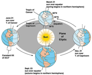
Equinoxes (March 21 and September 23)
- On these dates, the Sun is directly above the Equator, resulting in equal day and night durations.
- March 21: Spring Equinox in the Northern Hemisphere, Autumn Equinox in the Southern Hemisphere.
- September 23: Autumn Equinox in the Northern Hemisphere, Spring Equinox in the Southern Hemisphere.
| PYQs
Ques. In the Northern Hemisphere, the longest day of the year normally occurs in the: (2022)
Answer: B Ques. On 21st June, the Sun (2019)
Answer: A |