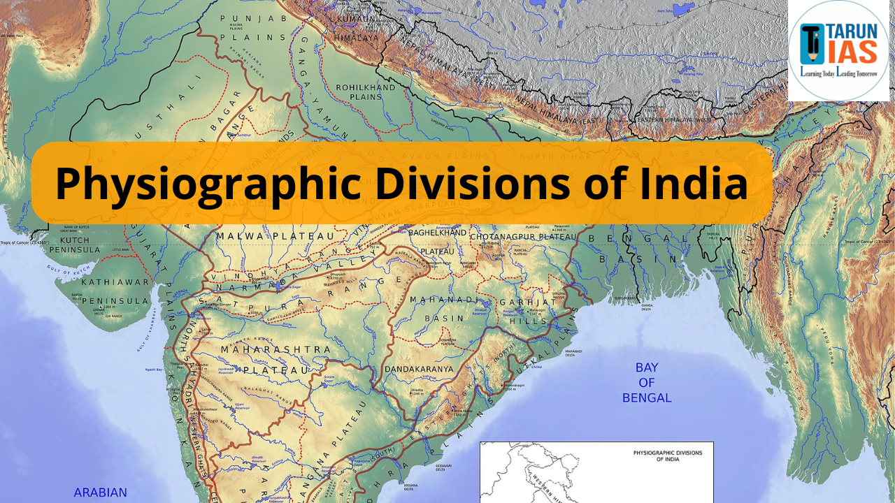
Physiographic Divisions of India represent the country’s diverse landscapes and cultural richness. India, one of the world’s oldest civilizations, stretches from the snow-covered Himalayas in the north to the warm coastal regions in the south. On the west, the vast Thar Desert marks its arid zone, while in the east, the fertile Brahmaputra valley enriches the land. The southwest is covered with dense tropical forests along the coast, showing how varied the physiographic divisions are. Geographically, the mainland lies roughly between 8°4′ N to 37°6′ N latitudes and 68°7′ E to 97°25′ E longitudes, giving India a stretch of about 2933 km from east to west and nearly 3214 km from north to south.
Physiographic Divisions of India are also influenced by latitudinal and longitudinal extent. The Tropic of Cancer (23°30′ N) passes almost through the middle of the country, dividing it into northern and southern halves. It crosses states such as Gujarat, Rajasthan, Madhya Pradesh, Chhattisgarh, Jharkhand, West Bengal, Tripura, and Mizoram. Because of the wide longitudinal spread, there is nearly a two-hour time difference between India’s eastern and western ends. To maintain uniformity, 82°30′ E longitude has been chosen as the Standard Meridian of India, passing through Mirzapur in Uttar Pradesh near Allahabad. The Indian Standard Time (IST) is calculated from this meridian and remains 5 hours 30 minutes ahead of GMT.
What is Physiography?
Physiography is the study of the physical features of the earth’s surface. It is closely linked with geology because the structure of rocks and tectonic movements decide how mountains, plains, plateaus, and rivers are formed.
physiography tells us about mountains, valleys, rivers, plains, and plateaus of a region. By studying them, we can understand how landforms control climate, vegetation, human life, and economic activities.
Physiographic Divisions of India
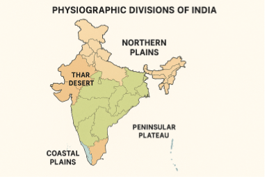
India is a land of great physical diversity. Based on its natural landforms, India can be divided into six major physiographic divisions:
| Physiographic Division | Key Features |
| Northern and North-Eastern Mountains | Himalayas, Purvanchal, young fold mountains |
| Northern Plains | Formed by Indus, Ganga, Brahmaputra rivers |
| Peninsular Plateau | Oldest and largest division, includes Deccan Plateau |
| Indian Desert | The Thar Desert with sand dunes and arid climate |
| Coastal Plains | Long coastline along Arabian Sea and Bay of Bengal |
| Islands | Andaman & Nicobar in Bay of Bengal, Lakshadweep in Arabian Sea |
Physiographic Divisions of India Northern and North-Eastern Mountains Plateau
The Himalayas are the youngest fold mountains of the world. They were formed when the Indo-Australian Plate collided with the Eurasian Plate millions of years ago. They act as a natural barrier between India and Central Asia, and also as a watershed for rivers like the Ganga and Brahmaputra.
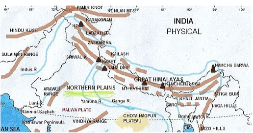
Latitudinal Divisions of the Himalayas
- Trans Himalayas – Includes Karakoram, Ladakh, and Zaskar ranges, lying north of the Great Himalayas and known for high peaks and cold deserts.
- Himalayan Mountain Ranges – Consist of Himadri (highest snow-covered peaks), Himachal (hill towns and valleys), and Shiwalik (outermost foothills).
- Eastern Hills / Purvanchal – Made up of Patkai, Naga, Manipur, and Mizo hills, forming folded low mountains with dense forests in the northeast.
Longitudinal Divisions of the Himalayas
- Punjab Himalayas – Stretch between the Indus and Satluj rivers, mainly covering Himachal Pradesh and Jammu & Kashmir.
- Kumaon Himalayas – Located between the Satluj and Kali rivers, lying mostly in Uttarakhand.
- Nepal Himalayas – Spread between the Kali and Tista rivers, known for the world’s highest peaks including Mount Everest.
- Assam Himalayas – Extend from the Tista to the Dihang river, forming the easternmost part of the Himalayas.
The Himalayas are important for their snow-fed rivers, fertile soil in plains, biodiversity, forest wealth, and defense importance.
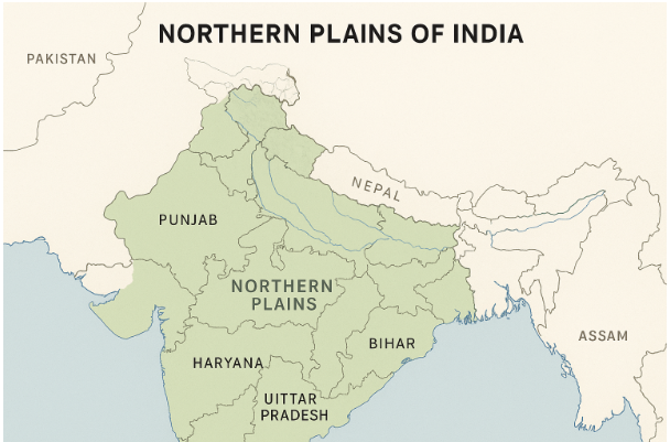
Physiographic Divisions of India Northern Plains of India
Northern Plains, also called the Indo-Gangetic-Brahmaputra Plains, lie to the south of the Himalayas. They were formed by alluvial deposits of Indus, Ganga, and Brahmaputra rivers and their tributaries.
- They extend for about 3200 km east to west.
- They are very fertile and support a dense population and agriculture.
Regional Divisions
- Rajasthan Plain – Dry plain region in the west, forming part of the Thar Desert with sandy soil and arid climate.
- Punjab-Haryana Plain – Fertile doab region formed by Indus tributaries, ideal for wheat and rice cultivation.
- Ganga Plain – The largest alluvial plain, extending from Uttarakhand to West Bengal, highly fertile and densely populated.
- Brahmaputra Plain – Wide and fertile plain in Assam, formed by the Brahmaputra river with frequent floods and rich biodiversity.
Geographical Features of Northern Plains
- Bhabar – Narrow belt of pebbles near Shiwalik foothills
- Tarai – Marshy area south of Bhabar, rich in wildlife
- Alluvial Plains – Khadar (new alluvium, fertile) and Bhangar (old alluvium)
These plains are known as the “food bowl of India” due to their fertile soil.
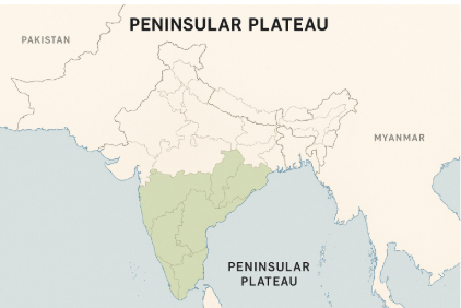
Physiographic Divisions of India Peninsular Plateau of India
Peninsular Plateau is the oldest and most stable landmass of India. It is made up of old crystalline rocks and formed from the breaking of the ancient Gondwana landmass.
- Average height: 600–900 meters
- Shape: Triangular
- Bounded by Aravallis in northwest, Rajmahal Hills in east, Cardamom Hills in south, and Gir Hills in west.
Major Plateaus
- Marwar Upland – A dry rocky plateau lying east of the Aravallis in Rajasthan.
- Central Highlands – Includes Malwa, Bundelkhand, and Baghelkhand plateaus, formed by old hard rocks.
- Chotanagpur Plateau – Mineral-rich plateau in Jharkhand and nearby areas, famous for coal, iron, and mica.
- Meghalaya (Shillong) Plateau – Separated from the main plateau by the Garo-Rajmahal gap, known for heavy rainfall.
- Deccan Plateau – Largest plateau of India, volcanic in origin, covering peninsular India.
- Chhattisgarh Plain – Fertile lowland within the plateau region, drained by the Mahanadi river.
Major Hill Ranges
- Aravali Range – The world’s oldest folded mountains, stretching across Rajasthan to Delhi.
- Vindhyan Range – Runs east–west, forming a natural divide between northern and southern India.
- Satpura Range – Parallel to the Vindhyas, rich in forests and minerals, with the Narmada valley in between.
- Western Ghats (Sahyadris) – Steep mountain chain along the west coast, known for biodiversity and heavy rainfall.
- Eastern Ghats – Discontinuous hills along the east coast, cut by rivers like the Godavari and Krishna.
The Deccan Trap region of the plateau has black soil formed by volcanic rocks, useful for cotton cultivation.
Physiographic Divisions of India Indian Desert
Indian Desert, or Thar Desert, is located to the northwest of the Aravalli Hills, covering Rajasthan and parts of Gujarat. It is characterized by sandy terrain, extreme climate, scarce rainfall, and sparse vegetation. The Thar Desert lies to the northwest of Aravalli Hills.
- Location – Situated northwest of the Aravalli Hills, covering most of Rajasthan and parts of Gujarat.
- Rainfall – Receives very low rainfall, generally less than 150 mm annually.
- Vegetation – Supports sparse vegetation, mostly thorny bushes and xerophytic plants.
- Landforms – Characterized by sand dunes, mushroom rocks, and scattered oases.
- River – The only significant seasonal river is the Luni, which flows through the desert.
It is also called Marusthali. Despite the harsh climate, it is rich in solar energy, wind energy, and mineral resources.
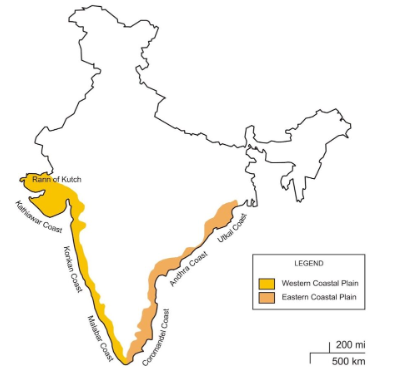
Physiographic Divisions of India Coastal Plains of India
India has about 6000 km long coastline. The coastal plains lie between the Peninsular Plateau and the seas.
Western Coastal Plains
- Location – Stretch along the Arabian Sea from Gujarat to Kerala.
- Width – Narrow and uneven coastal strip between the Western Ghats and the sea.
- Kachchh & Kathiawar Coast (Gujarat) – Known for marshy lands, salt flats, and the Gulf regions.
- Konkan Coast (Maharashtra) – Narrow rugged coast with numerous creeks and harbors.
- Goan Coast (Karnataka) – Famous for sandy beaches, estuaries, and tourism.
- Malabar Coast (Kerala) – Wide and fertile coast with backwaters, lagoons, and high rainfall.
Eastern Coastal Plains
- Location – Stretch along the Bay of Bengal from West Bengal to Tamil Nadu.
- Width – Much wider than the Western Coastal Plains.
- Rivers & Deltas – Famous for the deltas of the Mahanadi, Godavari, Krishna, and Kaveri rivers.
- Agriculture – Extremely fertile, well-suited for rice cultivation.
The coastal plains are important for ports, trade, tourism, agriculture, and fisheries.
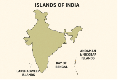
Physiographic Divisions of India Islands of India
While the Andaman and Nicobar Islands in the Bay of Bengal highlight India’s strategic and ecological importance, the Lakshadweep Islands in the Arabian Sea showcase its cultural richness, economic activities, and natural beauty. India has two main groups of islands.
Andaman and Nicobar Islands (Bay of Bengal)
- Location – Group of about 572 islands situated in the Bay of Bengal.
- Division – Separated into Andaman and Nicobar groups by the 10° Channel.
- Biodiversity – Covered with dense forests and home to rich flora and fauna.
- Strategic Role – Hold great strategic importance for India’s maritime security and defense.
Lakshadweep Islands (Arabian Sea)
- Location – A group of 36 small islands in the Arabian Sea, mostly of coral origin.
- Largest Island – Minicoy is the biggest and southernmost island of the group.
- Economy – Famous for coconut cultivation, rich fisheries, and beautiful lagoons.
Importance of Physiographic Divisions of India
Physiographic divisions shape India’s economy, culture, biodiversity, and strategic position, making them the backbone of the nation’s geographical identity.
| Division | Importance |
| Himalayas | Source of rivers, climate barrier, forests, defense, biodiversity |
| Northern Plains | Fertile soil, agriculture, dense population |
| Peninsular Plateau | Minerals, forests, rivers, power resources |
| Indian Desert | Solar/wind energy, minerals, tourism |
| Coastal Plains | Ports, trade, fisheries, agriculture |
| Islands | Defense, biodiversity, tourism |
Conclusion
Physiographic divisions of India show how nature has shaped the country’s landforms in different ways. From the snow-covered Himalayas to the fertile plains, the old Peninsular Plateau, the dry desert, the long coastal plains, and scattered islands each region has its own role in India’s development.
Physiographic Divisions of India FAQs

Which physiographic division of India is the oldest?
Peninsular Plateau is the oldest physiographic division of India, formed from the ancient Gondwana landmass. It is rich in minerals, forests, and rivers, making it an economic backbone. Its uneven surface includes hills, plateaus, and river valleys.
Why are the Northern Plains called the food bowl of India?
Northern Plains are called the food bowl of India because their fertile alluvial soil, abundant water from perennial rivers, and favorable climate make them ideal for growing a variety of crops. They produce large quantities of rice, wheat, sugarcane, and pulses, feeding a major share of India’s population.
What is the importance of the Himalayas in India?
Himalayas are of great importance to India as they act as a climatic barrier, preventing cold winds from Central Asia and bringing rainfall through monsoons. They are the source of perennial rivers, provide rich forests and biodiversity, and serve as a strong natural defense barrier for the country.
Which islands of India are made of coral deposits?
Lakshadweep Islands in the Arabian Sea are made of coral deposits, forming atolls, reefs, and lagoons. They are famous for their marine biodiversity, fisheries, and tourism potential.