Maharashtra, located in the western part of India, is one of the country’s most industrialized and populous states. The state is divided into districts for administrative purposes, each with its own unique characteristics in terms of geography, culture, population, and economic activities. Maharashtra has a total of 36 districts and 6 administrative divisions.
We will delve into various topics related to the districts of Maharashtra, including the number of districts, talukas, population statistics, the largest and smallest districts, and more.
Maharashtra State
Maharashtra, located in western India, is the second-most populous state. It has a rich cultural heritage, with Mumbai as its capital, known as the financial hub. The state boasts diverse landscapes, from beaches to mountains, historical landmarks, and a thriving economy, playing a key role in India’s development.
How Many Districts are in Maharashtra?
As of 2025, Maharashtra has 36 districts. These districts are further divided into smaller administrative units called talukas or tehsils. The districts are grouped into 6 divisions for better governance and administration.
These 6 divisions are:
- Mumbai (Konkan)
- Pune (Western Maharashtra)
- Nashik (Khandesh)
- Aurangabad (Marathwada)
- Amravati (Vidarbha)
- Nagpur (Vidarbha).
List of All Districts in Maharashtra (2025)
Here is a list of all 36 districts of Maharashtra as of 2025:
| 1. Ahmednagar | 2. Akola | 3. Amravati |
| 4. Aurangabad | 5. Beed | 6. Bhandara |
| 7. Buldhana | 8. Chandrapur | 9. Dhule |
| 10. Gadchiroli | 11. Gondia | 12. Hingoli |
| 13. Jalgaon | 14. Jalna | 15. Kolhapur |
| 16. Latur | 17. Mumbai City | 18. Mumbai Suburban |
| 19. Nandurbar | 20. Nanded | 21. Nashik |
| 22. Osmanabad | 23. Palghar | 24. Parbhani |
| 25. Pune | 26. Raigad | 27. Ratnagiri |
| 28. Sangli | 29. Satara | 30. Sindhudurg |
| 31. Solapur | 32. Thane | 33. Wardha |
| 34. Washim | 35. Yavatmal | 36. Nagpur |
How Many Talukas in Maharashtra?
Maharashtra is divided into 355 talukas (sub-districts). Each taluka serves as a local administrative unit within the districts. Talukas are responsible for revenue administration, and they play a key role in the implementation of government schemes and policies.
Maharashtra Districts Map
A district map of Maharashtra visually represents the 36 districts and their geographical locations. The map highlights the division boundaries and provides a clear understanding of where each district is situated in the state. Some of the key districts in Maharashtra include Mumbai, Pune, Nagpur, Thane, and Nashik, which are prominent in terms of economic development, industry, and culture.
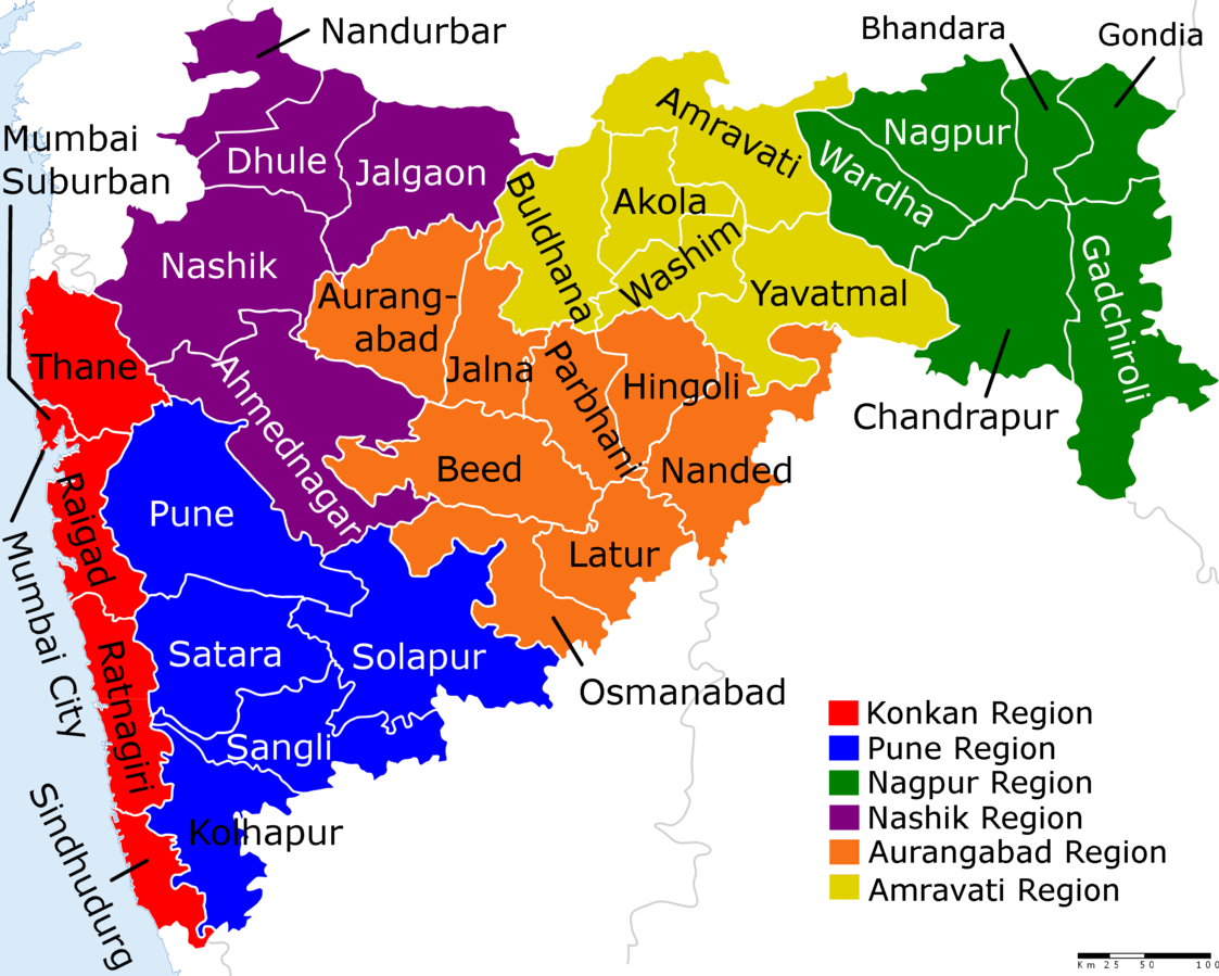
Image Credit: Wikipedia
Districts of Maharashtra with Area and Population 2025
The population of Maharashtra’s districts varies significantly, with urban districts typically having higher populations compared to rural districts. Here is a table with the districts of Maharashtra and their population according to the 2011 Census.
| S. No. | District | Area | Population |
| 1. | Ahmednagar | 17,048 | 4,543,159 |
| 2. | Akola | 5,428 | 1,813,906 |
| 3. | Amravati | 12,235 | 2,888,445 |
| 4. | Aurangabad | 10,100 | 3,701,282 |
| 5. | Beed | 10,693 | 2,585,049 |
| 6. | Bhandara | 3,707 | 1,200,334 |
| 7. | Buldhana | 9,661 | 2,486,258 |
| 8. | Chandrapur | 11,443 | 2,204,307 |
| 9. | Dhule | 7,195 | 2,050,862 |
| 10. | Gadchiroli | 14,412 | 1,072,942 |
| 11. | Gondia | 5,234 | 1,322,507 |
| 12. | Hingoli | 4,526 | 1,177,345 |
| 13. | Jalgaon | 11,765 | 4,229,917 |
| 14. | Jalna | 7,687 | 1,959,046 |
| 15. | Kolhapur | 7,685 | 3,876,001 |
| 16. | Latur | 7,157 | 2,454,196 |
| 17. | Mumbai City | 157 | 3,085,411 |
| 18. | Mumbai Suburban | 446 | 9,356,962 |
| 19. | Nagpur | 9,892 | 4,653,570 |
| 20. | Nanded | 10,528 | 3,361,292 |
| 21. | Nandurbar | 5,955 | 1,648,295 |
| 22. | Nashik | 15,582 | 6,107,187 |
| 23. | Osmanabad | 7,569 | 1,657,576 |
| 24. | Palghar | 5,344 | 29,95,428 |
| 25. | Parbhani | 6,251 | 1,836,086 |
| 26. | Pune | 15,643 | 9,429,408 |
| 27. | Raigad | 7,152 | 2,634,200 |
| 28. | Ratnagiri | 8,208 | 1,615,069 |
| 29. | Sangli | 8,578 | 2,822,143 |
| 30. | Satara | 10,480 | 3,003,741 |
| 31. | Sindhudurg | 5,207 | 849,651 |
| 32. | Solapur | 14,895 | 4,317,756 |
| 33. | Thane | 4,214 | 11,060,148 |
| 34. | Wardha | 6,310 | 1,300,774 |
| 35. | Washim | 5,150 | 1,197,160 |
| 36. | Yavatmal | 13,582 | 2,772,348 |
Smallest District in Maharashtra by Population
The smallest district in Maharashtra by population is Sindhudurg, with a population of approximately 849,651, is the least populous district in Maharashtra. Situated along the western coast, it is known for its scenic beauty, including beaches, forests, and a rich cultural history, making it a popular tourist destination despite its smaller population.
Highest Population District in Maharashtra
The highest population district in Maharashtra is Thane with a population of approximately 11.06 million as per the latest available data. Located near Mumbai, Thane is a rapidly growing urban area, benefiting from its proximity to the financial capital of India, which has led to substantial urban migration and development.
Smallest District in Maharashtra by Area
The smallest district in Maharashtra by area is Mumbai City.
- Area: 603 km²
- Overview: Mumbai City, although geographically small, is the most densely populated district in Maharashtra and serves as the center of economic and cultural activities in the state.
Largest District in Maharashtra by Area
The largest district in Maharashtra by area is Ahmednagar.
- Area: 17,048 km²
- Overview: Ahmednagar, located in the western part of Maharashtra, is one of the largest districts by land area. It is known for its historical significance, educational institutions, and agricultural land.
Top 5 Largest Districts in Maharashtra by Area
Here are the Top 5 Largest Districts in Maharashtra by Area:
- Ahmednagar – 17,048 km²
- Gadchiroli – 14,412 km²
- Solapur – 14,895 km²
- Yavatmal – 13,582 km²
- Amravati – 12,235 km²
Districts of Maharashtra with Significant Industries
Many districts in Maharashtra are known for their thriving industries and commerce. Some of the prominent industrial districts include:
- Pune: Known for its automobile, IT, and education sectors.
- Mumbai: The financial capital of India, hosting a variety of industries, including finance, entertainment, and textiles.
- Nagpur: A hub for agriculture, trading, and power generation.
- Nashik: Famous for its grape cultivation, winemaking, and manufacturing industries.
- Aurangabad: Known for its automotive and engineering industries, and also for historical tourism.
Related Articles |
|
|---|---|
| National Sports Awards 2024 | |
| UPSC Current Affairs Questions | |
Districts of Maharashtra FAQs
Q1. How many districts are there in Maharashtra?
Answer: Maharashtra has 36 districts as of 2025, organized into six administrative divisions for effective governance.
Q2. How many talukas are in Maharashtra?
Answer: Maharashtra is divided into 355 talukas, which are administrative subunits under each district.
Q3. What is the list of all districts in Maharashtra (2025)?
Answer: The state has 36 districts, including prominent ones like Pune, Thane, Mumbai City, Nagpur, and Nashik.
Q4. Which is the largest district in Maharashtra by area?
Answer: Ahmednagar is the largest district in Maharashtra by area, covering 17,048 km².
Q5. Which is the smallest district in Maharashtra by area?
Answer: Mumbai City is the smallest district in Maharashtra by area, covering only 157 km².