Uttar Pradesh (UP) is one of the largest and most populous states in India, located in the northern part of the country. It is known for its rich cultural heritage, historical significance, and economic importance. The state is divided into 75 districts, which are further categorized into divisions for administrative convenience.
We will explore various aspects related to the districts of Uttar Pradesh, including the number of districts, a list of all districts, a map, the largest and smallest districts, and their populations.
Uttar Pradesh State
Uttar Pradesh is located in the northern part of India. It is bordered by the states of Haryana, Delhi, Rajasthan, Madhya Pradesh, Chhattisgarh, Bihar, and Jharkhand. To the north, it shares a border with the country of Nepal. The state is centrally located in the northern plains, making it one of the most strategically and culturally significant regions in India. Its capital is Lucknow, and other major cities include Varanasi, Agra, and Kanpur. UP lies to the east of Rajasthan and west of Bihar on the map of India.
How Many Districts in Uttar Pradesh (UP)?
As of 2025, Uttar Pradesh has 75 districts. These districts are spread across 18 divisions, and each district is an administrative unit with its own local governance and regional focus. The state’s capital is Lucknow, and each district plays a crucial role in the state’s economy, culture, and administration.
75 Districts of Uttar Pradesh 2025
Here is a list of all 75 districts of Uttar Pradesh as of 2025, arranged alphabetically:
| 1. Agra | 2. Aligarh | 3. Allahabad (Prayagraj) | 4. Ambedkar Nagar | 5. Amethi |
| 6. Amroha | 7. Auraiya | 8. Azamgarh | 9. Baghpat | 10. Bahraich |
| 11. Ballia | 12. Balrampur | 13. Banda | 14. Barabanki | 15. Bareilly |
| 16. Basti | 17. Bhadohi | 18. Bijnor | 19. Budaun | 20. Bulandshahr |
| 21. Chandauli | 22. Chitrakoot | 23. Deoria | 24. Etah | 25. Etawah |
| 26. Faizabad (Ayodhya) | 27. Farrukhabad | 28. Firozabad | 29. Gautam Buddha Nagar (Noida) | 30. Ghaziabad |
| 31. Gorakhpur | 32. Hamirpur | 33. Hapur | 34. Hardoi | 35. Jhansi |
| 36. Jalaun | 37. Jaunpur | 38. Jhansi | 39. Kannauj | 40. Kanpur Dehat |
| 41. Kanpur Nagar | 42. Kasganj | 43. Kaushambi | 44.Kushinagar | 45. Lakhimpur Kheri |
| 46. Lalitpur | 47. Lucknow | 48. Mua | 49. Meerut | 50. Mirzapur |
| 51. Moradabad | 52. Muzaffarnagar | 53. Pilibhit | 54. Pratapgarh | 55. Rae Bareli |
| 56. Rampur | 57. Saharanpur | 58. Sambhal | 59. Sant Kabir Nagar | 60. Sant Ravidas Nagar |
| 61. Shahjahanpur | 62. Shamli | 63. Shravasti | 64. Siddharthnagar | 65. Sitapur |
| 66.
Sonbhadra |
67. Sultanpur | 68. Unnao | 69. Varanasi | 70. Shamli |
| 71. Mau | 72. Gorakhpur | 73. Aligarh | 74. Fatehpur | 75. Bulandshahr |
Largest Districts in Uttar Pradesh (by Area)
The largest district in Uttar Pradesh by area is Lakhimpur Kheri. Covering an area of approximately 7,680 square kilometers, it is situated in the northern part of the state. Known for its agricultural land, Lakhimpur Kheri is rich in crops like sugarcane, wheat, and rice.
Top 5 largest districts (by area) in Uttar Pradesh are:
- Lakhimpur Kheri – 7,680 square kilometers
- Sonbhadra – 6,905 square kilometers
- Hardoi – 5,986 square kilometers
- Prayagraj – 5,482 square kilometers
- Jhansi – 5,024 square kilometers
Smallest Districts in Uttar Pradesh (by Area)
The smallest district in Uttar Pradesh by area is Hapur. Located in the western part of the state, it spans an area of approximately 1,535 square kilometers. Known for its proximity to Delhi, Hapur is a key agricultural hub, producing crops like sugarcane, wheat, and vegetables.
Top 5 smallest districts (by area) in Uttar Pradesh are:
- Hapur – 649 square kilometers
- Gautam Buddha Nagar – 720 square kilometers
- Shamli – 1,266 square kilometers
- Bagpat – 1,321 square kilometers
- Bhadohi – 1,646 square kilometers
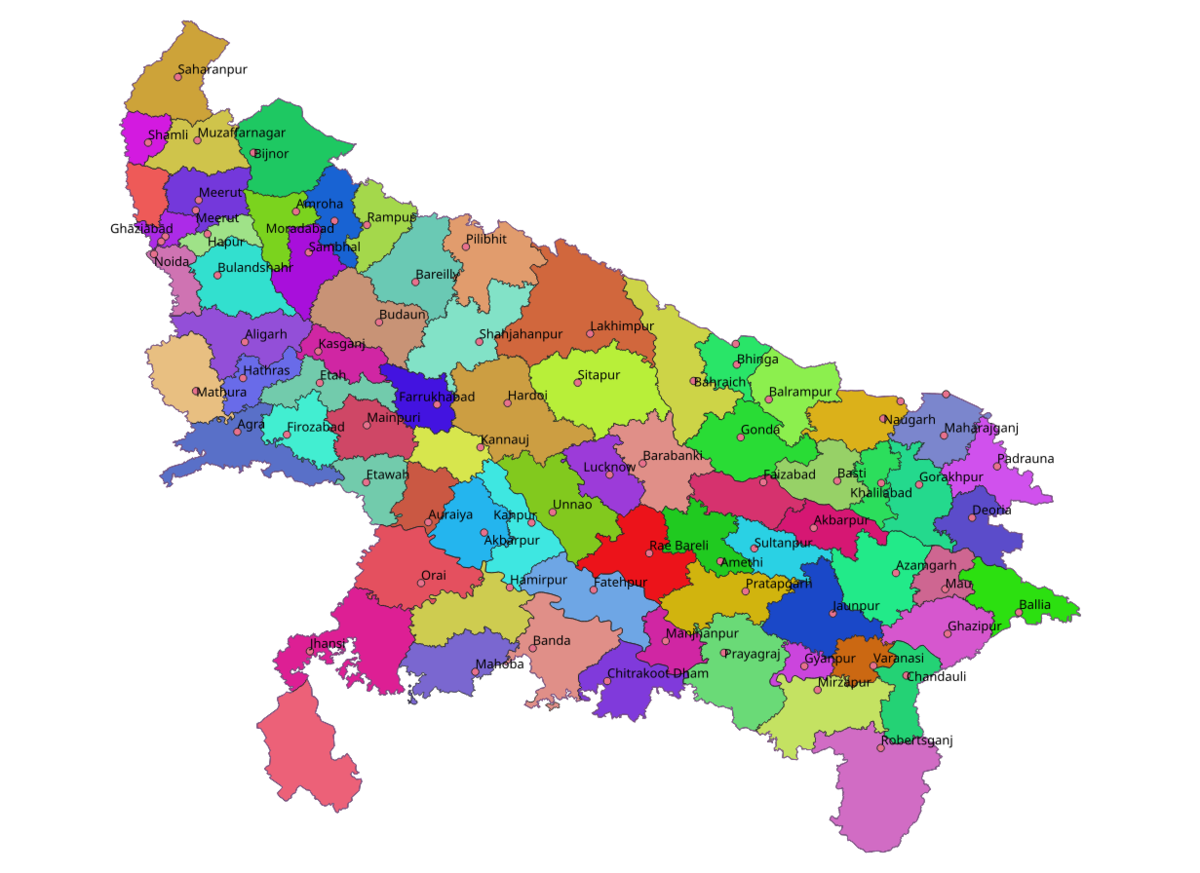
UP District Map UP District Map (2025)
The district map of Uttar Pradesh outlines the 75 districts and their geographical locations. The map provides clarity on the boundaries and locations of major cities and administrative divisions. The districts of Uttar Pradesh are typically categorized into 18 divisions. These divisions help in the administrative organization of the state. Some well-known divisions include Kanpur, Allahabad (Prayagraj), Meerut, Lucknow, and Varanasi.
List of Districts of Uttar Pradesh with Area and Population
Here is a table listing the districts of Uttar Pradesh along with their approximate populations, based on the most recent census data (Census 2011). Please note that population figures may have slightly changed since then, and more current data can be obtained from official government sources.
| S.No. | District | Area | Population |
| 1. | Agra | 4,041 | 4,418,797 |
| 2. | Aligarh | 3,788 | 3,673,889 |
| 3. | Ambedkar Nagar | 2,350 | 2,397,888 |
| 4 | Ayodhya | 2,555 | 2,470,996 |
| 5. | Amethi | 2,329 | 2,050,133 |
| 6. | Amroha | 2,249 | 1,840,221 |
| 7. | Auraiya | 2,016 | 1,379,545 |
| 8. | Azamgarh | 4,054 | 4,613,913 |
| 9. | Budaun | 4,234 | 3,127,621 |
| 10. | Bagpat | 1,321 | 1,303,048 |
| 11. | Bahraich | 2,981 | 3,487,731 |
| 12. | Ballia | 3,349 | 3,239,774 |
| 13. | Balrampur | 4,408 | 2,148,665 |
| 14. | Banda | 4,402 | 1,799,410 |
| 15. | Barabanki | 4,120 | 3,260,699 |
| 16. | Bareilly | 2,688 | 4,448,359 |
| 17. | Basti | 4,561 | 2,464,464 |
| 18. | Bijnor | 4,262 | 3,682,713 |
| 19. | Bulandshahr | 4,441 | 3,499,171 |
| 20. | Chandauli | 2,541 | 1,952,756 |
| 21. | Chitrakoot | 3,216 | 991,730 |
| 22. | Deoria | 2,540 | 3,100,946 |
| 23. | Etah | 2,431 | 1,774,480 |
| 24. | Etawah | 2,311 | 1,581,810 |
| 25. | Farrukhabad | 2,181 | 1,885,204 |
| 26. | Fatehpur | 4,152 | 2,632,733 |
| 27. | Firozabad | 2,407 | 2,498,156 |
| 28. | Gautam Buddha Nagar | 720 | 1,648,115 |
| 29. | Ghaziabad | 1,179 | 3,343,334 |
| 30. | Ghazipur | 3,377 | 3,620,268 |
| 31. | Gonda | 4,003 | 3,433,919 |
| 32. | Gorakhpur | 3,321 | 4,440,895 |
| 33. | Hamirpur | 4,021 | 1,104,285 |
| 34. | Hapur | 649 | 1,338,311 |
| 35. | Hardoi | 5,986 | 4,092,845 |
| 36. | Hathras | 1,840 | 1,564,708 |
| 37. | Jalaun | 4,565 | 1,689,974 |
| 38. | Jaunpur | 4,038 | 4,494,204 |
| 39. | Jhansi | 5,024 | 1,998,603 |
| 40. | Kannauj | 2,093 | 1,656,616 |
| 41. | Kanpur Dehat | 3,021 | 1,796,184 |
| 42. | Kanpur Nagar | 3,155 | 4,581,268 |
| 43. | Kasganj | 1,955 | 1,436,719 |
| 44. | Kaushambi | 1,779 | 1,599,596 |
| 45. | Kushinagar | 2,905 | 4,021,243 |
| 46. | Lakhimpur Kheri | 7,680 | 3,564,544 |
| 47. | Lalitpur | 5,039 | 1,221,592 |
| 48. | Lucknow | 2,528 | 4,589,838 |
| 49. | Maharajganj | 2,952 | 2,684,703 |
| 50. | Mahoba | 3,144 | 875,958 |
| 51. | Mainpuri | 2,760 | 1,868,529 |
| 52. | Mathura | 3,340 | 2,547,184 |
| 53. | Mau | 1,713 | 2,205,968 |
| 54. | Meerut | 2,559 | 3,443,689 |
| 55. | Mirzapur | 4,405 | 2,496,970 |
| 56. | Moradabad | 2,233 | 3,126,507 |
| 57. | Muzaffarnagar | 2,742 | 2,869,934 |
| 58. | Pilibhit | 3,686 | 2,031,007 |
| 59. | Pratapnagar | 3,717 | 3,209,141 |
| 60. | Prayagraj | 5,482 | 5,954,391 |
| 61. | Rae Bareli | 3,937 | 2,903,507 |
| 62. | Rampur | 2,367 | 2,335,819 |
| 63. | Saharanpur | 3,689 | 3,466,382 |
| 64. | Sant Kabir Nagar | 2,390 | 2,199,774 |
| 65. | Bhadohi | 1,646 | 1,715,183 |
| 66. | Sambhal | 1,015 | 1,578,213 |
| 67. | Shahjahanpur | 4,388 | 3,006,538 |
| 68. | Shamli | 1,266 | 1,273,578 |
| 69. | Shravasti | 1,640 | 1,117,361 |
| 70. | Siddharthnagar | 2,895 | 2,559,297 |
| 71. | Sitapur | 5,743 | 4,483,992 |
| 72. | Sonbhadra | 6,905 | 1,862,559 |
| 73. | Sultanpur | 2,457 | 2,249,036 |
| 74. | Unnao | 4,558 | 3,108,367 |
| 75. | Varanasi | 1,535 | 3,676,841 |
Related Articles |
|
|---|---|
| UPSC Mains Paper II | |
| UPSC Mains GS Paper I | |
Districts Of Uttar Pradesh FAQs
Q1: How many districts are there in Uttar Pradesh?
Answer: Uttar Pradesh consists of 75 districts, each contributing to the state’s diversity in terms of culture, geography, and administration, with varying populations and local characteristics.
Q2: What is the population of Uttar Pradesh?
Answer: Uttar Pradesh, with a population of over 200 million (Census 2011), is the most populous state in India, contributing significantly to the country’s demographic and electoral significance.
Q3: What languages are spoken in Uttar Pradesh?
Answer: Hindi is the most widely spoken language in Uttar Pradesh, while Urdu, Bhojpuri, Awadhi, and other regional dialects are also commonly spoken across the state.
Q4: What are the major rivers in Uttar Pradesh?
Answer: Uttar Pradesh is home to major rivers like the Ganges, Yamuna, Gomti, and Saryu, which play a crucial role in the state’s agriculture, transportation, and religious significance.
Q5: What is the historical significance of Agra?
Answer: Agra is historically significant for being home to the Taj Mahal, a UNESCO World Heritage Site, and other Mughal-era monuments, making it a key tourist and cultural center.