Uttar Pradesh (UP) is one of the largest and most populous states in India, located in the northern part of the country. It is known for its rich cultural heritage, historical significance, and economic importance. The state is divided into 75 districts, which are further categorized into divisions for administrative convenience.
We will explore various aspects related to the districts of Uttar Pradesh, including the number of districts, a list of all districts, a map, the largest and smallest districts, and their populations.
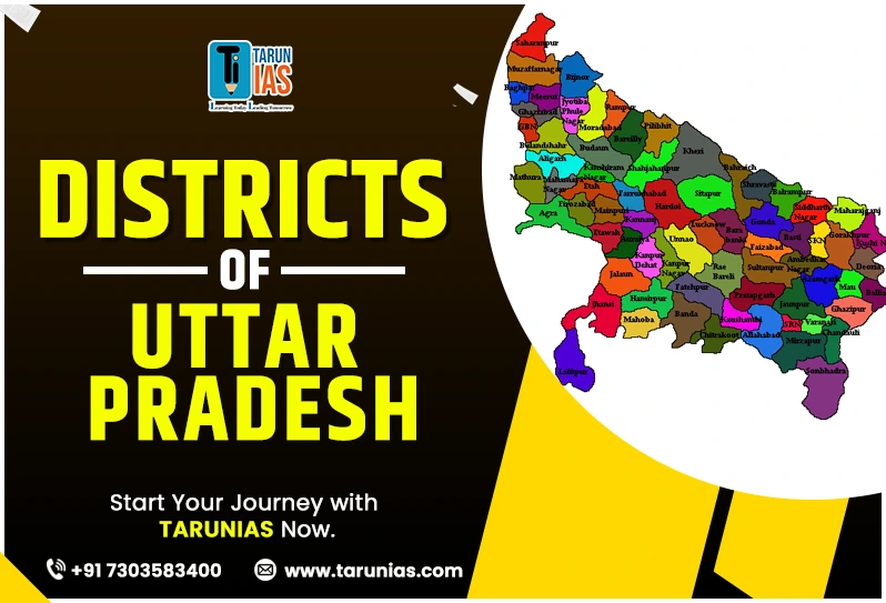
Explore the Districts Of Uttar Pradesh with Map 2025
Uttar Pradesh is located in the northern part of India. Uttar Pradesh shares its border with 8 states and 1 union territory which is maximum. Delhi, Haryana, Himachal Pradesh, and Uttarakhand in North, Bihar Jharkhand in the east, Rajasthan in West and Madhya Pradesh and Chattisgarh in the south. To the north, it shares a border with the country of Nepal. The state is centrally located in the northern plains, making it one of the most strategically and culturally significant regions in India. Its capital is Lucknow, and other major cities include Varanasi, Agra, and Kanpur. UP lies to the east of Rajasthan and west of Bihar on the map of India.
Also Read: Indian States and Union Territories their Capitals Language 2025
How Many Districts in Uttar Pradesh (UP)?
As of 2025, Uttar Pradesh has 75 districts. These districts are spread across 18 divisions, and each district is an administrative unit with its own local governance and regional focus. The state’s capital is Lucknow, and each district plays a crucial role in the state’s economy, culture, and administration.

Credit: Wikipedia
75 Districts of Uttar Pradesh 2025
Here is a list of all 75 districts of Uttar Pradesh as of 2025, arranged alphabetically:
| 1. Agra | 2. Aligarh | 3. Allahabad (Prayagraj) | 4. Ambedkar Nagar | 5. Amethi |
| 6. Amroha | 7. Auraiya | 8. Azamgarh | 9. Baghpat | 10. Bahraich |
| 11. Ballia | 12. Balrampur | 13. Banda | 14. Barabanki | 15. Bareilly |
| 16. Basti | 17. Bhadohi | 18. Bijnor | 19. Budaun | 20. Bulandshahr |
| 21. Chandauli | 22. Chitrakoot | 23. Deoria | 24. Etah | 25. Etawah |
| 26. Faizabad (Ayodhya) | 27. Farrukhabad | 28. Firozabad | 29. Gautam Buddha Nagar (Noida) | 30. Ghaziabad |
| 31. Gorakhpur | 32. Hamirpur | 33. Hapur | 34. Hardoi | 35. Jhansi |
| 36. Jalaun | 37. Jaunpur | 38. Jhansi | 39. Kannauj | 40. Kanpur Dehat |
| 41. Kanpur Nagar | 42. Kasganj | 43. Kaushambi | 44.Kushinagar | 45. Lakhimpur Kheri |
| 46. Lalitpur | 47. Lucknow | 48. Mua | 49. Meerut | 50. Mirzapur |
| 51. Moradabad | 52. Muzaffarnagar | 53. Pilibhit | 54. Pratapgarh | 55. Rae Bareli |
| 56. Rampur | 57. Saharanpur | 58. Sambhal | 59. Sant Kabir Nagar | 60. Sant Ravidas Nagar |
| 61. Shahjahanpur | 62. Shamli | 63. Shravasti | 64. Siddharthnagar | 65. Sitapur |
| 66.
Sonbhadra |
67. Sultanpur | 68. Unnao | 69. Varanasi | 70. Shamli |
| 71. Mau | 72. Gorakhpur | 73. Aligarh | 74. Fatehpur | 75. Bulandshahr |
Largest Districts in Uttar Pradesh (by Area)
The largest district in Uttar Pradesh by area is Lakhimpur Kheri. Covering an area of approximately 7,680 square kilometers, it is situated in the northern part of the state. Known for its agricultural land, Lakhimpur Kheri is rich in crops like sugarcane, wheat, and rice.
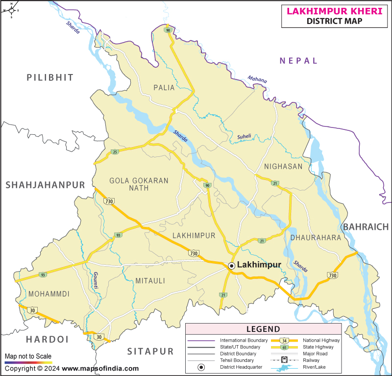
Credit: www.mapsofindia.com
Top 5 largest districts (by area) in Uttar Pradesh are:
- Lakhimpur Kheri – 7,680 square kilometers
- Sonbhadra – 6,905 square kilometers
- Hardoi – 5,986 square kilometers
- Prayagraj – 5,482 square kilometers
- Jhansi – 5,024 square kilometers
Smallest Districts in Uttar Pradesh (by Area)
The smallest district in Uttar Pradesh by area is Hapur. Located in the western part of the state, it spans an area of approximately 1,535 square kilometers. Known for its proximity to Delhi, Hapur is a key agricultural hub, producing crops like sugarcane, wheat, and vegetables.
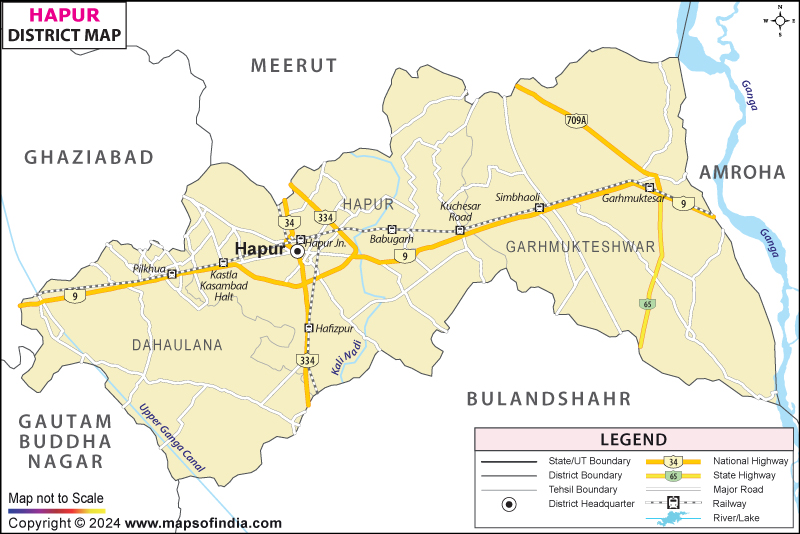
Image Credit- Maps of India
Top 5 smallest districts (by area) in Uttar Pradesh are:
- Hapur – 649 square kilometers
- Gautam Buddha Nagar – 720 square kilometers
- Shamli – 1,266 square kilometers
- Bagpat – 1,321 square kilometers
- Bhadohi – 1,646 square kilometers
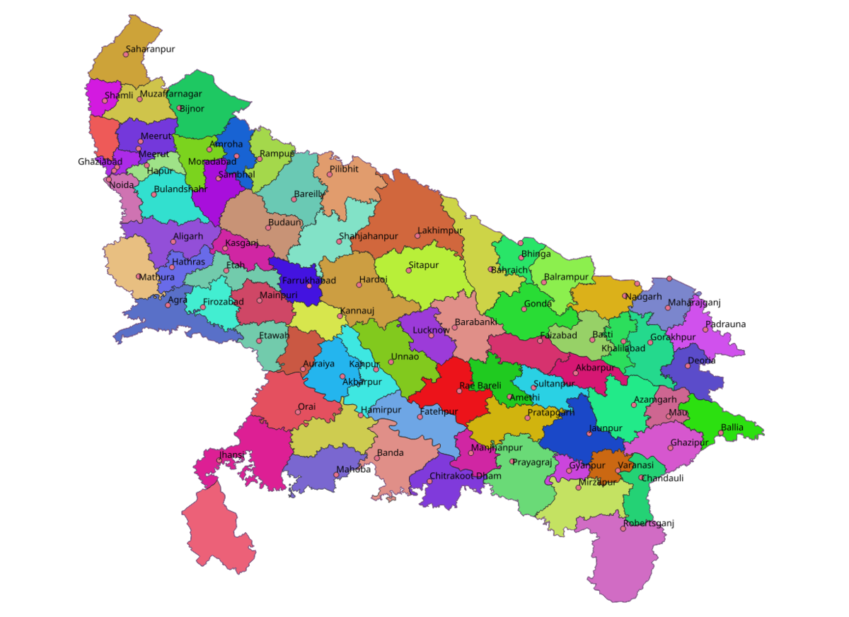
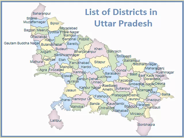
UP District Map UP District Map 2025
The district map of Uttar Pradesh outlines the 75 districts and their geographical locations. The map provides clarity on the boundaries and locations of major cities and administrative divisions. The districts of Uttar Pradesh are typically categorized into 18 divisions. These divisions help in the administrative organization of the state. Some well-known divisions include Kanpur, Allahabad (Prayagraj), Meerut, Lucknow, and Varanasi.
List of Districts of Uttar Pradesh with Area and Population
Here is a table listing the districts of Uttar Pradesh along with their approximate populations, based on the most recent census data (Census 2011). Please note that population figures may have slightly changed since then, and more current data can be obtained from official government sources.
| S.No. | District | Area | Population |
| 1. | Agra | 4,041 | 4,418,797 |
| 2. | Aligarh | 3,788 | 3,673,889 |
| 3. | Ambedkar Nagar | 2,350 | 2,397,888 |
| 4 | Ayodhya | 2,555 | 2,470,996 |
| 5. | Amethi | 2,329 | 2,050,133 |
| 6. | Amroha | 2,249 | 1,840,221 |
| 7. | Auraiya | 2,016 | 1,379,545 |
| 8. | Azamgarh | 4,054 | 4,613,913 |
| 9. | Budaun | 4,234 | 3,127,621 |
| 10. | Bagpat | 1,321 | 1,303,048 |
| 11. | Bahraich | 2,981 | 3,487,731 |
| 12. | Ballia | 3,349 | 3,239,774 |
| 13. | Balrampur | 4,408 | 2,148,665 |
| 14. | Banda | 4,402 | 1,799,410 |
| 15. | Barabanki | 4,120 | 3,260,699 |
| 16. | Bareilly | 2,688 | 4,448,359 |
| 17. | Basti | 4,561 | 2,464,464 |
| 18. | Bijnor | 4,262 | 3,682,713 |
| 19. | Bulandshahr | 4,441 | 3,499,171 |
| 20. | Chandauli | 2,541 | 1,952,756 |
| 21. | Chitrakoot | 3,216 | 991,730 |
| 22. | Deoria | 2,540 | 3,100,946 |
| 23. | Etah | 2,431 | 1,774,480 |
| 24. | Etawah | 2,311 | 1,581,810 |
| 25. | Farrukhabad | 2,181 | 1,885,204 |
| 26. | Fatehpur | 4,152 | 2,632,733 |
| 27. | Firozabad | 2,407 | 2,498,156 |
| 28. | Gautam Buddha Nagar | 720 | 1,648,115 |
| 29. | Ghaziabad | 1,179 | 3,343,334 |
| 30. | Ghazipur | 3,377 | 3,620,268 |
| 31. | Gonda | 4,003 | 3,433,919 |
| 32. | Gorakhpur | 3,321 | 4,440,895 |
| 33. | Hamirpur | 4,021 | 1,104,285 |
| 34. | Hapur | 649 | 1,338,311 |
| 35. | Hardoi | 5,986 | 4,092,845 |
| 36. | Hathras | 1,840 | 1,564,708 |
| 37. | Jalaun | 4,565 | 1,689,974 |
| 38. | Jaunpur | 4,038 | 4,494,204 |
| 39. | Jhansi | 5,024 | 1,998,603 |
| 40. | Kannauj | 2,093 | 1,656,616 |
| 41. | Kanpur Dehat | 3,021 | 1,796,184 |
| 42. | Kanpur Nagar | 3,155 | 4,581,268 |
| 43. | Kasganj | 1,955 | 1,436,719 |
| 44. | Kaushambi | 1,779 | 1,599,596 |
| 45. | Kushinagar | 2,905 | 4,021,243 |
| 46. | Lakhimpur Kheri | 7,680 | 3,564,544 |
| 47. | Lalitpur | 5,039 | 1,221,592 |
| 48. | Lucknow | 2,528 | 4,589,838 |
| 49. | Maharajganj | 2,952 | 2,684,703 |
| 50. | Mahoba | 3,144 | 875,958 |
| 51. | Mainpuri | 2,760 | 1,868,529 |
| 52. | Mathura | 3,340 | 2,547,184 |
| 53. | Mau | 1,713 | 2,205,968 |
| 54. | Meerut | 2,559 | 3,443,689 |
| 55. | Mirzapur | 4,405 | 2,496,970 |
| 56. | Moradabad | 2,233 | 3,126,507 |
| 57. | Muzaffarnagar | 2,742 | 2,869,934 |
| 58. | Pilibhit | 3,686 | 2,031,007 |
| 59. | Pratapnagar | 3,717 | 3,209,141 |
| 60. | Prayagraj | 5,482 | 5,954,391 |
| 61. | Rae Bareli | 3,937 | 2,903,507 |
| 62. | Rampur | 2,367 | 2,335,819 |
| 63. | Saharanpur | 3,689 | 3,466,382 |
| 64. | Sant Kabir Nagar | 2,390 | 2,199,774 |
| 65. | Bhadohi | 1,646 | 1,715,183 |
| 66. | Sambhal | 1,015 | 1,578,213 |
| 67. | Shahjahanpur | 4,388 | 3,006,538 |
| 68. | Shamli | 1,266 | 1,273,578 |
| 69. | Shravasti | 1,640 | 1,117,361 |
| 70. | Siddharthnagar | 2,895 | 2,559,297 |
| 71. | Sitapur | 5,743 | 4,483,992 |
| 72. | Sonbhadra | 6,905 | 1,862,559 |
| 73. | Sultanpur | 2,457 | 2,249,036 |
| 74. | Unnao | 4,558 | 3,108,367 |
| 75. | Varanasi | 1,535 | 3,676,841 |
Divisions of Uttar Pradesh (18 in Total)
To make administration more efficient, the 75 districts of Uttar Pradesh are organized into 18 divisions.These divisions help manage governance, law and order, and development programs across the state.
| Division | Major Districts |
| Agra | Agra, Mathura, Firozabad, Mainpuri |
| Aligarh | Aligarh, Etah, Hathras, Kasganj |
| Ayodhya | Ayodhya, Ambedkar Nagar, Barabanki, Gonda, Basti |
| Azamgarh | Azamgarh, Mau, Ballia |
| Bareilly | Bareilly, Badaun, Pilibhit, Shahjahanpur |
| Basti | Basti, Sant Kabir Nagar, Siddharthnagar |
| Chitrakoot Dham | Banda, Chitrakoot, Hamirpur, Mahoba |
| Devipatan | Bahraich, Shravasti, Balrampur, Gonda |
| Gorakhpur | Gorakhpur, Deoria, Kushinagar, Maharajganj |
| Jhansi | Jhansi, Lalitpur, Jalaun |
| Kanpur | Kanpur Nagar, Kanpur Dehat, Auraiya, Etawah |
| Lucknow | Lucknow, Raebareli, Hardoi, Unnao, Sitapur, Lakhimpur Kheri |
| Meerut | Meerut, Ghaziabad, Gautam Buddha Nagar, Baghpat, Bulandshahr, Hapur |
| Mirzapur | Mirzapur, Sonbhadra, Bhadohi |
| Moradabad | Moradabad, Amroha, Bijnor, Rampur, Sambhal |
| Prayagraj | Prayagraj, Kaushambi, Fatehpur, Pratapgarh |
| Saharanpur | Saharanpur, Muzaffarnagar, Shamli |
| Varanasi | Varanasi, Ghazipur, Jaunpur, Chandauli |
Population Insights (Latest Projections 2025)
As per Census 2011, UP’s population was 199.8 million. Based on growth trends, the estimated population in 2025 is around 240–245 million, making it India’s most populous state.
Major Infrastructure & Connectivity Initiatives
Uttar Pradesh is witnessing rapid growth with several major infrastructure and connectivity projects underway.
- High-Speed Corridor from Ayodhya to Varanasi
The NHAI has begun preparing a Detailed Project Report (DPR) for a 192 km access-controlled corridor between Ayodhya and Varanasi. This project is expected to significantly enhance travel efficiency and drive regional growth. - Ganga Expressway Progress Report
The 594 km, six-lane Ganga Expressway (connecting Meerut to Prayagraj) is nearing completion:- Earthwork: 99%
- GSB & WMM: 97%
- Main carriageway DBM: 96%
- Structures completed: 1,489 out of 1,500
Overall project progress is at about 89%.
- Upper Ganges Canal Expressway Get Approved
The UP government has approved the eight-lane Upper Ganges Canal Expressway, linking Bulandshahr (Noida) to Haridwar via Muzaffarnagar, paving the way for future construction.
Transport & Smart Mobility Enhancements
Uttar Pradesh is transforming its transport sector with digital reforms, smart mobility solutions, and modern infrastructure upgrades.
- Digital Transport Reforms Launched
CM Yogi Adityanath unveiled several transport initiatives:- Digital Bus Tracking via “Margdarshi” app
- Saral Transport Helpline (149)
- E-ticketing across 14,000 UPSRTC buses via CSCs
- Introduction of over 80 modern buses across fuel types (electric, CNG, AC, double-decker), and
- Foundation of seven modern bus stations under PPP.
Economic, Tech & Industrial Growth
Uttar Pradesh is rapidly emerging as a hub for industrial expansion, technological innovation, and startup growth.
- Boosting Cement Manufacturing
Massive infrastructure growth has made UP the largest cement consumer in India. Investments worth ₹3,228 crore have been committed under IIEPP-2022, with major players like JK Cement, Shree Cement, UltraTech, and ACC scaling up operations. - Ambitious Tech & Startup Vision
UP aims to foster 15-20 decacorns (₹10B+ firms) by 2047. Key targets:- AI cities in Lucknow and Kanpur
- Incubation centers in every division
- Partnering with ISRO for satellite-enabled disaster management
- Upskilling 40 million youth in deep tech areas
- Aerospace & Defence Investment Policy
The state cleared a landmark Aerospace & Defence Unit and Employment Promotion Policy, aiming to attract ₹50,000 crore in investments and generate 100,000 jobs. It offers substantial land and capital subsidies, with a special focus on startups and women entrepreneurs.
Education, Agriculture & Urban Development
Uttar Pradesh is driving holistic growth through major advancements in education, agriculture, and urban development.
- “Udgam” Digital Platform for Teachers
UP launched “Udgam” (Unifying Development of Great Academic Minds), a portal that enriches educational practices—covering pedagogy, vocational learning, tech, sports, and community engagement. Several teachers were honored during the launch. - Samarth Education Portal Rollout
The Samarth portal will become the sole administrative platform across colleges and universities in UP by 2025–26, phasing out private ERP systems and improving transparency in faculty promotions. - New Forestry University in Gorakhpur
The first-ever Forestry & Horticulture University in North India is being built in Gorakhpur. Spread over 50 hectares with a green campus, it has an allocated fund of ₹621 crore. - Guru Jambheshwar University Launch
UP’s new state university in Moradabad—named Guru Jambheshwar University—has been recognized by UGC and began academic operations in 2025 with 372 affiliated colleges. - Krishonnati Yojana Agriculture Push
Under Krishonnati Yojana, the Centre allocated ₹550 crore for UP (FY 2025–26), promoting digital farming, hybrid crop varieties, better irrigation systems, and mechanized tools via district-level targeting. - Five Strategic Seed Parks Planned
UP plans to launch five seed parks across agro-climatic zones (Western UP, Terai, Central UP, Bundelkhand, Eastern UP), with a ₹2,500 crore PPP-based rollout to boost high-quality seed supply.
Policy & Governance Highlights
Uttar Pradesh is introducing stricter policies and governance reforms to ensure better security, transparency, and administrative efficiency.
- Tougher Nepal-Boundary Immigration Rules
New rules effective from September 1 strengthen immigration control in UP, especially in seven Nepal-bordering districts. Measures include mandatory Form C/S, penalties, and digital tracking of foreign nationals
Social Welfare & Urban Enhancement
Uttar Pradesh is focusing on social welfare and urban transformation through innovative programs and massive infrastructure investments.
- Stray Dog Welfare Now Recognized
UP introduced a reward system for NGOs and urban local bodies excelling in stray dog sterilization, vaccination, and organized feeding—complete with impacted feeding points and humane oversight. - Urban Development: ₹25,000+ Crore Infusion
UP has earmarked ₹25,310 crore for urban beautification—enabling sports facilities, smart city elements, drainage infrastructure, and model municipalities in 17 key cities.
Districts Of Uttar Pradesh 2025 FAQs
What is the population of Uttar Pradesh?
Uttar Pradesh, with a population of over 200 million (Census 2011), is the most populous state in India, contributing significantly to the country's demographic and electoral significance.
What languages are spoken in Uttar Pradesh?
Hindi is the most widely spoken language in Uttar Pradesh, while Urdu, Bhojpuri, Awadhi, and other regional dialects are also commonly spoken across the state.
What are the major rivers in Uttar Pradesh?
Uttar Pradesh is home to major rivers like the Ganges, Yamuna, Gomti, and Saryu, which play a crucial role in the state's agriculture, transportation, and religious significance.
What is the historical significance of Agra?
Agra is historically significant for being home to the Taj Mahal, a UNESCO World
Related Articles |
|
|---|---|
| UPSC Mains Paper II | |
| UPSC Mains GS Paper I | |